
Places near here
Photo credits
- National Inventory of Architectural Heritage
- Willow, Wikimedia Commons · CC BY 2.5
- Colin Park, Geograph · CC BY-SA 2.0
- N Chadwick, Geograph · CC BY-SA 2.0
- Garry Dickinson, Wikimedia Commons · CC BY-SA 2.0
- N Chadwick, Wikimedia Commons · CC BY-SA 2.0
- Deemaykay, Wikimedia Commons · CC BY-SA 4.0
 Kilshane ChurchChurch/chapel · 15 yd
Explorer Tom Kilshane Church has a curse that only affects people who don’t wave when they pass by. The steeple is striking, but the ruin next door is basically saying 'we were here first.' Give it a little wave from the road, and make sure you actually do it this time.
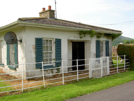 ArraghsleaGate lodge · 95 yd
Explorer Tom Arraghslea’s gate lodge has a curved door that looks like it’s trying to smile but mostly just looks confused about its own geometry. Its secret talent is probably judging your parking job from the porch while pretending to nap in the sun. It’s got sash windows that frame the view of you wondering why you’re there.
Site of Seefin CastleCastle, unclassified · 792 ydExplorer Tom Seefin Castle refuses to fall down because it’s hiding in the coniferous forest, giggling at our confusion. The 1654 survey says it was in good repair, which is a lie. Bring wellies and low expectations, leave delighted.
RathfaunEnclosure · 998 ydExplorer Tom Rathfaun is named after a faun who allegedly invented the concept of a semi-circle here. A local swears he built it himself in a weekend, which is a stretch, but hey, confidence. Go in good boots and better humour.
Bansha ForestForest · 1.1 miExplorer Tom Bansha Forest has a secret it would only tell after three pints of stout, which involves a castle that keeps moving its furniture. It’s a wood that likes to keep you guessing about what’s real and what’s just bad light. Perfect spot to practise your best tour-guide voice.
 European ash1.7 mi
Explorer Tom European ash in County Tipperary would order a full chippy with extra gravy and a side of chips shaped like its own leaves, because it likes to eat like a king. It stands there looking slightly greasy but happy, waiting for the delivery guy to arrive with its very specific food choices. Dare you to say hello to it out loud.
 The RockViewpoint · 2.5 mi
Explorer Tom The Rock in County Tipperary is probably where the map makers got it wrong because they were too scared to draw a line that close to the edge. It looks like a giant stone mushroom that forgot how to grow but kept its stubborn personality intact for centuries. Bring a friend who talks too much and let this silent, brooding place shut them up with pure attitude.
 Christ the KingViewpoint · 3.2 mi
Explorer Tom Christ the King has a hidden treasure that is definitely just an old biscuit tin filled with broken buttons, but everyone pretends otherwise. It’s the ultimate test of your faith and your pocket change collection. Bring a camera and your most suspicious face.
 Kilfeakle Castle (in ruins)Castle, tower house · 3.2 mi
Explorer Tom Kilfeakle Castle has a legend about a giant who got stuck in the chimney and left his boots there forever. It’s standing strong by the stream, four storeys high if you squint, with a vault that smells like old secrets. Hang around long enough and you'll hear a story from a local.
 Glen of AherlowViewpoint · 3.2 mi
Explorer Tom Glen of Aherlow is where the seagulls hold their weekly meetings to complain about the weather. The view from here makes you question if your own life has enough drama. Whisper a secret at it, it's kept worse.
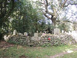 CrossCross, High cross · 3.7 mi
Explorer Tom Cross in Ardane is secretly proud of the potato growing right next to its base, which is very ironic for a holy site. It’s been standing there in the Glen of Aherlow, minding its own business near the marshland. Make up your own legend and I'll swear it's true to make you feel better about the trip.
 CushMountain / peak · 5.4 mi
Explorer Tom Cush is holding a massive grudge against the weather, convinced that every cloud it sees is personally aiming for its head. It’s been storming at the sky so much now that it’s actually got a permanent scowl etched into its granite soul. Snap one photo, then put the phone away and actually look around you, mate.
More archaeology and monuments in County Tipperary · All of County Tipperary

What do you know about this place?Tap to add a comment or ask a question