What is recorded here
Grave Yd. is a Kerry graveyard where Herbert and Rose Vincent dead have slept since the seventeenth century, beside a rebuilt chapel that may have swallowed an older church. Rudolph Raspe may also rest beneath the bushes, though no marker proves it. The oval pitch, narrow fosse and iron gates keep the hillock separate from the pasture, while chest-tombs and a stepped bellcote chamber the family dead in stone.
In pasture, on top of a hillock. The graveyard is an oval area (c. 95m NW-SE; c. 70m NE-SW) defined by a narrow fosse (Wth c. 2m; D c. 1.5m) cut into the hillside with stone facing on its internal face. There is a causeway entrance (Wth c. 9m) at SE, with wrought iron double gates. The fosse appears to be a recent feature. This is the burial place of the Herberts and Rose Vincents, families associated with Muckross House. An imitation High Cross, named 'monument' on the 1895 OS 6-inch map marks the burial place of Hernry Arthur Herbert who founded Muckross House. Large chest-tombs occupy most of the central area which is covered in bushes. Low uninscribed grave-markers occupy most of the SE area. The site of a church (KE066-082001-) is in the SW area and was possibly rebuilt as a family mortuary (KE066-082003-). According to Barrington (1976, 206), the German author Rudolph Raspe, was buried here in 1794 but the location of the grave is not known.
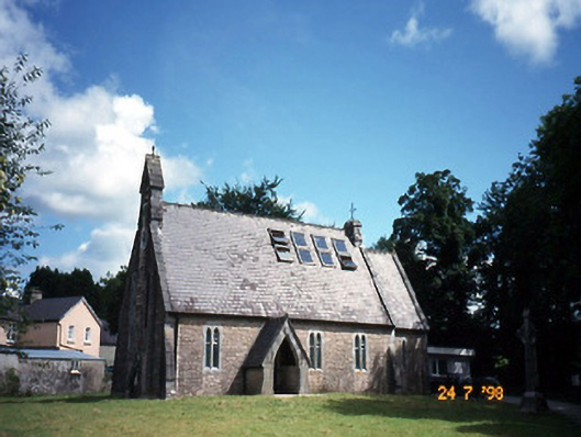
A rectangular mortuary chapel (7.45m E-W; 4.88m N-S) is rebuilt on or near the site of an earlier church (KE066-082001-) in the SW quadrant of the graveyard. A segmental-arched door ope at the W end of the N wall with a single cut-limestone jamb to E is possibly from the earlier church. A central window in the E wall has an arched embrasure with moulded corners and a round-headed sandstone light (Wth 0.2m; H 0.53m). The chapel has a pointed vaulted plank-centred roof with a corbel support for the centring in the N and S walls. The tower-like W gable is ornately stepped and topped with a bellcote. A wall plaque in the chapel reads the 'family mortuary chapel by Maurice Hussey of Cahernane … 1714'. Skinner (1945, 6) suggests the remains of the old church was converted into a family mortuary. However the earlier church (KE066-082001-) is indicated on the 1848 OS 6-inch map as a cruciform church in the SW quadrant of the graveyard.
Compiled by: Elizabeth Byrne, Ursula Egan and Sheila Ronan, Archaeological Survey Unit, University College, Cork.
Date of upload: 31 January 2011
Portal dolmen; dates to the Neolithic or early Bronze Age. Its construction and location suggest it was a ceremonial or funerary site, possibly used for communal burials.
The monument record does not grant public access. Check the route and ask the landowner before entering private land.
- What survives
- Recorded monument
Places near here
 Killegy Ch. (Site of)Church · 40 yd
 The Blue PoolGallery · 232 yd
 church/chapelchurch/chapel · 249 yd
 QuayQuay · 635 yd
 Wall monument in MuckrossWall monument · 689 yd
 Blue Pool Nature ReserveWood · 696 yd
 Muckross AbbeyHeritage attraction · 698 yd
 European YewEuropean Yew · 722 yd
 Osprey RockIsland · 1303 yd
 McCarthy Mor CastleCastle · 1448 yd
 Castlelough BayBay · 1526 yd
 A.W.B. (Billy) Vincent MemorialMemorial · 1740 yd