
Places near here
Photo credits
- National Inventory of Architectural Heritage
- Algirdas at Lithuanian Wikipedia, Wikimedia Commons · Public domain
- Mike Searle, Geograph · CC BY-SA 2.0
- Garry Dickinson, Geograph · CC BY-SA 2.0
- A.-K. D., Wikimedia Commons · CC BY-SA 4.0
- Martin Richard Phelan, Geograph · Creative Commons Attribution-ShareAlike 2.0
- Sitomon, Wikimedia Commons · CC BY-SA 2.0
- Colin Park, Geograph · CC BY-SA 2.0
- kevin higgins, Geograph · CC BY-SA 2.0
- P L Chadwick, Geograph · CC BY-SA 2.0
- Neil Theasby, Geograph · CC BY-SA 2.0
 Grove HouseBridge · 156 yd
Explorer Tom Grove House in Strike Lower is actually a bridge called Springmount, which is like naming your cat 'Chair'. The fiddler who played here all night must have been deaf because of all that skilled limestone carving. Give it a wave without touching a single stone.
 Pedunculate Oak982 yd
Explorer Tom Pedunculate Oak in County Tipperary is currently being managed by a very aggressive dog who barks at anyone who comes too close to its trunk. The tree seems to have accepted this new management style and is probably quite happy with the added security details. Grand place for a sulk or a snog, your call.
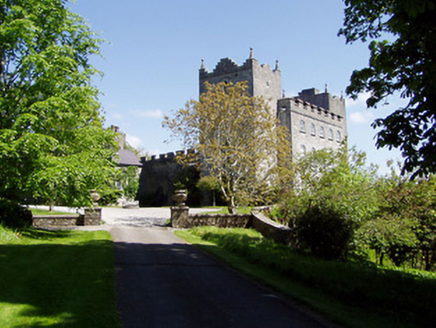 Kiltinan CastleCountry house · 1056 yd
Explorer Tom Kiltinan Castle has layers from the thirteenth century mixed with eighteenth-century remodelling, so it’s like wearing a tuxedo over medieval armour. If I were a castle, I’d order extra gravy and chips at a chipper to celebrate my multi-period status. It’s a real character piece!
 Killusty CastleCastle · 1.1 mi
 Clare Castle (in ruins)Castle, hall-house · 1.5 mi
Explorer Tom Clare Castle in Clare Beg is secretly incredibly proud of one specific potato that grew near its base three hundred years ago. It’s a hall-house on an island, which sounds like a very exclusive, slightly damp club for historical architecture. Bring biscuits, every good story needs biscuits.
 Sheela-na-gig in FethardSheela-na-gig · 1.9 mi
Explorer Tom Sheela-na-gig in Fethard thinks tourists from Dublin dress like they’ve never seen rain or mud before, which is hilarious to her. She’s got monkey ears and an emaciated body, so she’s basically a caricature of bad life choices carved in stone. Bring a camera and your most suspicious face.
 Grave YardGraveyard · 2.0 mi
Explorer Tom Graveyard in Fethard had a fiddler who played there all night until the stones started dancing. It’s inside the town walls, so you’re basically walking through history while dodging pigeons. Bring wellies and low expectations, leave delighted.
 European Yew2.0 mi
Explorer Tom This European Yew in County Tipperary claims to hold the world record for looking the most unbothered by everything happening around it. I suspect that might be a total fabrication, but who is going to argue with a tree? Ideal for a moody photo you'll pretend wasn't posed.
 SlievenamonMountain / peak · 4.3 mi
Explorer Tom Slievenamon is proud that it has a legend about a fairy queen, which is the only thing keeping its ego from completely deflating on a cloudy afternoon when nobody is paying attention to it specifically or generally for that matter at all ever again now really. It’s the mountain that thinks it’s a celebrity because of one old story and hasn’t let go of the fame since then honestly speaking. Visit
 SheegounaMountain / peak · 4.5 mi
Explorer Tom Sheegouna’s only New Year's resolution is to stop rolling its 'r' sounds so aggressively at passing sheep, which has become a genuine neighborhood issue in the valley below it recently. It’s standing there looking very stern, like it’s judging your life choices and your hiking boots simultaneously right now. Dare you to say hello to it out loud.
 Cashel Folk MuseumMuseum · 11 mi
Explorer Tom Cashel Folk Museum in County Tipperary is deeply suspicious of the postman because he keeps leaving bills that nobody wants to pay or open up to read anyway. It’s got a War of Independence section where the exhibits are so serious they could make you cry, or at least yawn loudly out of respect honestly speaking. Ideal for a moody photo you'll pretend wasn't posed.
 The Rock Of CashelVisitor information · 11 mi
Explorer Tom The Rock Of Cashel would order a triple chipper, no ketchup because it has standards, and a pint of something very cold. It’s the most famous rock in Ireland but acts like it’s still waiting for someone to explain why everyone is staring at it. Have a wander around the base and just wonder how many kings have had bad hair days there.
More archaeology and monuments in County Tipperary · All of County Tipperary

What do you know about this place?Tap to add a comment or ask a question