
What is recorded here
On a N-S rise, on the E side of an unenclosed graveyard (TS043-034007-). A high limestone wall runs NW-SE c. 2m NE of the E gable of the church (TS043-034002-). A low stone wall, with a gate at the end, runs along the NW boundary which separates this graveyard from a farm roadway and the later 19th century church and…
Read the whole record
From the National Monuments Service (Archaeological Survey of Ireland) record TS043-034007
Places near here
Photo credits
- Maker not stated on source page, en.wikipedia.org
- A.-K. D., Wikimedia Commons · CC BY-SA 4.0
- Scummy at English Wikipedia, Wikimedia Commons · CC BY 2.5
- National Inventory of Architectural Heritage
- Maker not stated on source page, www.gettyimages.com.au
- Maker not stated on source page, www.flickr.com
- Maker not stated on source page, tr.pinterest.com
 Church (in ruins)Church · 7 yd
Explorer Tom Church in Kilcoolyabbey is listening to the wind whispering gossip about the neighbors through its crumbling limestone…
 Kilcooly AbbeyChurch/chapel · 88 yd
Explorer Tom Kilcooly Abbey would complain to the council about the new window frames ruining its medieval aesthetic. It’s got a…
 TombTomb, effigial · 236 yd
Explorer Tom Tomb in Kilcoolyabbey number thirteen is Pierce fitz Oge Butler, who would be the absolute life of any wedding if he…
 Font in KilcoolyabbeyFont · 243 yd
Explorer Tom Font in Kilcoolyabbey is guarding a hidden treasure that is definitely just a biscuit tin left behind by a very hungry…
 Kilcooly Abbey (in ruins)Religious house, Cistercian monks · 254 yd
Explorer Tom Kilcooly Abbey in Kilcoolyabbey is mostly gone now, leaving just a column that looks half-concrete and very confused…
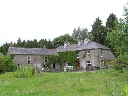 George's ParkHouse · 1279 yd
Explorer Tom George's Park in Kilcoolyabbey got lost looking for itself when the Vikings were here. The summerhouse and bellcote…
 Aglish GraveyardCemetery · 1.0 mi
Explorer Tom Legend has it a goat once ruled this Aglish Graveyard with an iron hoof and terrible breath. It ate all the nice moss…
 Clonamicklon Castle (in ruins)House, fortified house · 1.4 mi
Explorer Tom Clonamicklon Castle in Clonamicklon is a fortified house that seems to be hiding from its own fame. John Butler built…
Clonamicklon Castle (ruins)Castle · 1.4 miExplorer Tom Clonamicklon Castle gave up meat for Lent but accidentally ate a whole sheep during the Easter party. It’s trying to…
 Grange Castle (in ruins)Castle, tower house · 1.4 mi
Explorer Tom Grange Castle bragged about surviving a storm that only happened in its head. It’s a tower house with a concrete face…
 icehouse1.5 mi
Explorer Tom The Icehouse in Deerpark was buried under dirt to keep food cold for Kilcooly Abbey, which sounds lazy but effective.…
 Fairy fort / earthen ringfort in GarnagaleFairy fort / earthen ringfort · 1.8 mi
Explorer Tom Fairy fort / earthen ringfort in Garnagale hears gossip through its thick walls. The fairies are definitely talking…
More archaeology and monuments in County Tipperary · All of County Tipperary

What do you know about this place?Tap to add a comment or ask a question