
Places near here
Photo credits
- National Inventory of Architectural Heritage
- Duncan Grant, Wikimedia Commons · CC BY-SA 2.0
- David Purchase, Geograph · Creative Commons Attribution-ShareAlike 2.0
- Jon Sullivan, Wikimedia Commons · CC0
- Oliver Dixon, Geograph · CC BY-SA 2.0
Explorer Tom Bockagh Hill bragged about surviving a storm so bad it made the clouds cry and quit their jobs for a while. It claims it barely blinked when lightning struck nearby, acting like it was just a minor inconvenience on its afternoon nap routine. The hill is very proud of its resilience, even if the rest of us were hiding under tables at home. Ideal spot for a dramatic phone call.
 farm house2.3 mi
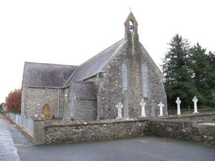 Saint James's Catholic ChurchChurch/chapel · 2.3 mi
Explorer Tom Saint James’s Catholic Church would tell its younger self to stop trying so hard to look medieval and just be itself. It’s spent years polishing its sparrow-pecked surfaces, but it still looks a bit unsure of its own style. Give it a pat on the head from a distance.
Castle (ruins)Castle, unclassified · 3.3 miExplorer Tom Castle in Glebe has a family tree that’s mostly made up of people who lost arguments. The Costellos held it for ages before handing the keys to someone who didn’t read the manual. Bring someone who'll believe anything.
Old Cave Burial GroundArchaeological place · 3.8 miCastleCastle, unclassified · 4.0 miExplorer Tom Castle in Kilcolman took about two million cups of tea to build, judging by the sheer amount of effort involved. It got destroyed three times, which proves that stubbornness doesn't always equal safety. Whisper a secret at it, it's kept worse.
 CashelFairy fort / stone ringfort · 4.1 mi
Explorer Tom Another cashel in Kilcashel stands tall on the ridge, looking down its nose at everyone else with its thick, sturdy drystone walls. The builder was definitely thinking about views when they stacked those rocks, ignoring the wind and the cold completely. Bring biscuits, every good story needs biscuits.
Crow IslandIslet · 8.1 miExplorer Tom Crow Island has been keeping secrets for centuries, mostly about who actually stole the vicar's hat in 1923, but it would spill everything after two pints. It’s just too shy to admit it. Bring your worst joke, the place has heard worse.
Castle PointHeadland · 8.3 miExplorer Tom Castle Point in County Sligo is currently embroiled in a fairy dispute over parking rights, with tiny wings buzzing angrily around the lighthouse foundation. They’ve drawn lines in the sand that definitely weren’t there yesterday and are very upset about boundary violations. Find the wonkiest bit and send it to your group chat.
 Grave YardGraveyard · 10 mi
Explorer Tom Graveyard in Aghamore would post a photo of its mossy headstones with the caption 'Living my best quiet life, #ancient'. It’s got that moody, atmospheric vibe going on that makes you feel instantly profound. Have a wander and a wonder.
 Caves of KeshCave · 11 mi
Explorer Tom The weather has a long-standing grudge against Caves of Kesh, constantly trying to collapse it to prove a point about structural integrity. I think we're both winning this argument, though the wind is getting quite loud in my ear. Find the date carved somewhere and feel clever.
 Kesh CorannMountain / peak · 12 mi
Explorer Tom Kesh Corann in County Sligo is basically the uncle at the wedding who won't stop talking about his harpist ancestor. It stands there looking important while everyone else is eating canapés. Have a sandwich here and call it a heritage lunch.
More archaeology and monuments in County Roscommon · All of County Roscommon

What do you know about this place?Tap to add a comment or ask a question