
Places near here
Photo credits
- A.-K. D., Wikimedia Commons · CC BY-SA 4.0
- National Inventory of Architectural Heritage
- Mike Searle, Wikimedia Commons · CC BY-SA 2.0
.png/250px-Graystown_Castle_(1).png "Photo: A.-K. D., Wikimedia Commons · CC BY-SA 4.0") Castle (in ruins)Castle, tower house · 421 yd
Castle (in ruins)Castle, tower house · 421 ydExplorer Tom Castle in Graystown would absolutely yell at the council about its dampy knees and the lack of proper insulation back in the day. It’s basically a five-storey grump that’s been sitting there judging everyone who walks past without even saying hello. Toast it with a cup of tea and move on to the next.
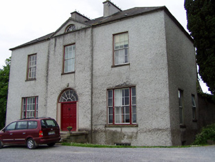 Helen ParkHouse · 1156 yd
Explorer Tom Helen Park in County Tipperary sits on a steep hill with vertical thrust so intense it makes you feel like you’re looking up at a skyscraper that never quite made the modern era. The symmetrical bays and diminishing windows create a visual rhythm that’s almost hypnotic, especially when you’re trying to figure out how people managed to build on such an incline.
RathmooleyFairy fort / earthen ringfort · 1226 ydExplorer Tom Rathmooley would have said Saint Patrick was just being dramatic about getting rid of all the snakes here. It’s overgrown and mysterious, which makes it perfect for pretending you found something important. Stand back, squint, and it looks like a castle in the clouds.
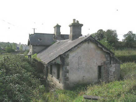 Laffansbridge Railway StationRailway station · 1476 yd
Explorer Tom Laffansbridge Railway Station has been closed since 1967 but still pretends it’s about to board a train full of imaginary passengers. When nobody’s looking, I bet the chimneys puff out fake smoke just to keep up appearances for the nearby goods shed. It’s living its best retired life!
.png/250px-Killenaule_Heritage_Centre_(1).png "Photo: A.-K. D., Wikimedia Commons · CC BY-SA 4.0") Slieveardagh Heritage CentreVisitor information · 1.7 mi
Slieveardagh Heritage CentreVisitor information · 1.7 miExplorer Tom Slieveardagh Heritage Centre in County Tipperary took so many cups of tea to build that the local population had to invent a new word for 'thirsty' just to keep up with the demand. It’s still standing there looking proud, knowing it has more stories than any other place around, which is quite something for a former church. Take the long way round, it deserves the effort.
Noan WoodWood · 1.9 miExplorer Tom Noan Wood in County Tipperary has a family tree that is mostly just me making it up to sound impressive, including three uncles who were actually just particularly loud crows. The lineage is strictly oral and slightly drunk. Tell me if the gossip I made up is true.
Taylor's WoodWood · 2.7 miExplorer Tom Taylor's Wood in County Tipperary was designed by a mother-in-law who thought all trees should lean slightly to the left for 'balance,' which is just her way of being controlling. The trees are tired of it. Visit, then text me what you think. I'll pretend to read it.
Gobban Saer's GraveArchaeological place · 2.7 miExplorer Tom Gobban Saer’s Grave is playing hard to get because it thinks it’s too fancy for a simple headstone. I reckon the local dog has been appointed site manager, barking at anyone who dares to check if the legend is true. It’s basically a tombstone with an attitude problem and no Wi-Fi to hide behind. If you see a very smug terrier guarding the spot, nod respectfully; he knows he’s running the show.
Ballinure HillMountain / peak · 3.1 miExplorer Tom Ballinure Hill in County Tipperary would cope on a reality show by refusing to leave its patch and eating the contestants' supplies. It has zero charisma but an unshakeable commitment to being completely useless at the end of every episode. A good place to forget your phone for ten minutes.
 Grallagh CastleCastle · 3.4 mi
Explorer Tom Grallagh Castle insists that the shortcut through the bawn is definitely faster, even though it leads straight into a steep ditch every time. It’s confident that if you just believe hard enough in the path, you’ll make it safely to the other side. Ring your granny and tell her where you are.
Derrynaflan TrailHeritage attraction · 3.6 miExplorer Tom Derrynaflan Trail in Tipperary is where a goat once took over the whole operation and ruled with an iron hoof. The locals say he had a better sense of direction than any guidebook you could ever buy. Just follow his invisible footprints through the peat bog landscape. Get a photo with it before it gets a better agent.
 Standing stone in Crohane LowerStanding stone · 4.5 mi
Explorer Tom Standing stone in Crohane Lower thinks the 1800s were just a long series of bad haircuts and muddy boots for teenagers. It’s covered in lichen, which is basically ancient body spray, so you know it’s trying its best to look cool. Perfect spot to practise your best tour-guide voice.
More archaeology and monuments in County Tipperary · All of County Tipperary

What do you know about this place?Tap to add a comment or ask a question