What is recorded here
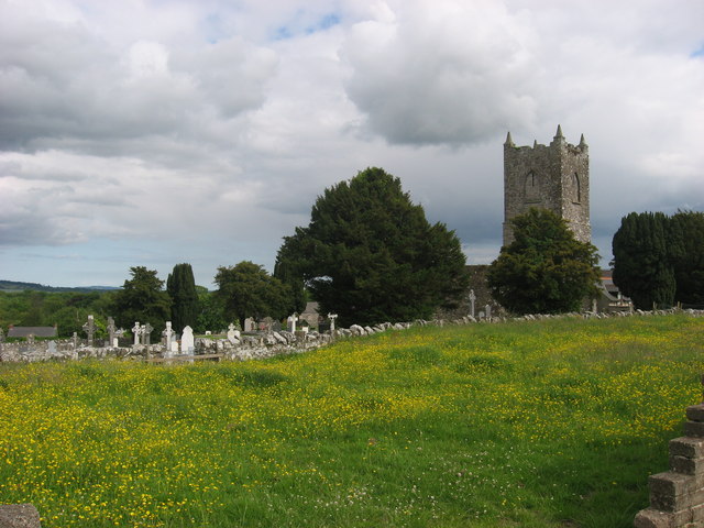
Situated on an elevated position in the village of Garristown. Large, roughly rectangular-shaped (dims. c. 73m N-S x 65m E-W) graveyard enclosed by a post 1700 wall with entrance gate in centre of N wall and a second gate in SE corner. A stone stile is present at NE and SE corners. Modern graveyard extension to W. A late 19th century church (1888) stands in the SW quadrant, possibly on the site of the medieval parish church of Garristown (DU011-011001-) (Lewis 1837 1, 650; Walsh 1888, 245). The oldest graveslabs appear in the S of the graveyard. Those with inscriptions date from the 17th to the 21st century. A fragment of a possible 15th-century effigial tomb (DU003-011004-) was uncovered in 1990 and is now housed in Garristown library. At least four rainwater chutes (DU003-011005-) possibly from the medieval church are now visible in the graveyard where they appear to have been reused as grave-markers. The graveyard is still in use and has been extended to the west.
Situated on an elevated position in the village of Garristown. Large, roughly rectangular-shaped (dims. c. 73m N-S x 65m E-W) graveyard enclosed by a post 1700 wall with entrance gate in centre of N wall and a second gate in SE corner. A stone stile is present at NE and SE corners. Modern graveyard extension to W. A late 19th century church (1888) stands in the SW quadrant, possibly on the site of the medieval…
From the National Monuments Service (Archaeological Survey of Ireland) record DU003-011003
The monument record does not grant public access. Check the route and ask the landowner before entering private land.
- What survives
- Recorded monument
Places near here
Photo credits
- Dvcireland, Wikimedia Commons · CC BY-SA 4.0
- Offdaw, Wikimedia Commons · CC BY-SA 4.0
- Kieran Campbell, Geograph · CC BY-SA 2.0
- SeoR, Wikimedia Commons · CC BY-SA 4.0
- C O'Flanagan, Geograph · CC BY-SA 2.0
 TombTomb, effigial · 8 yd
 Garristown ChurchChurch/chapel · 10 ydChurch (in Ruins)Church · 13 yd
 Windmill861 ydNewtown GorseWood · 1.1 miNewtown HillMountain / peak · 1.7 miThe story of the milk standMemorial · 2.3 miPuddenhillHeritage attraction · 2.3 mi
 FourknocksPassage tomb · 2.8 mi
 Westown HouseCastle, tower house · 3.7 mi
 Seamus Ennis Cultural CentreMemorial · 4.1 mi
 Athcarne CastleCastle, tower house · 4.4 mi
More archaeology and monuments in County Dublin · All of County Dublin
What do you know about this place?