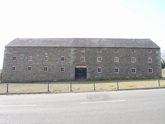
What is recorded here
Detached nine-bay three-storey grain store or warehouse, extant 1840, on a rectangular plan originally four- or five-bay three-storey. Now disused. Pitched slate roof with clay ridge tiles, lichen-spotted coping to gables, and no rainwater goods surviving on slate flagged eaves. Part creeper- or ivy-covered coursed rubble stone battered walls with benchmark-inscribed rough hewn granite flush quoins to corners; lime rendered surface finish to side (east) elevation. Square-headed central carriageway in elliptical- or segmental-headed recess with timber beam lintel framing timber boarded double doors. Square-headed window openings in camber-headed recesses with red brick block-and-start surrounds framing timber casement windows. Set back from line of road with verge to front.
A grain store or warehouse representing an important component of the industrial heritage of the outskirts of New Ross with the architectural value of the composition, one most likely erected in support of a diagonally opposing mill marked on the first edition of the Ordnance Survey (surveyed 1840; published 1841), confirmed by such attributes as rectilinear plan form; the somewhat disproportionate bias of solid to void in the massing compounded by the uniform or near-uniform proportions of the openings on each floor; and the high pitched roofline: meanwhile, a pronounced masonry break clearly illustrates the continued linear development of the grain store or warehouse. A prolonged period of neglect notwithstanding, the elementary form and massing survive intact together with substantial quantities of the historic or original fabric, both to the exterior and to the utilitarian interior, thus upholding the character or integrity of a grain store or warehouse making a pleasing visual statement in a rural street scene: meanwhile, a benchmark remains of additional interest for the connections with cartography and the preparation of maps by the Ordnance Survey (established 1824).
From the Buildings of Ireland (National Inventory of Architectural Heritage) record 15606003
This does not grant access. Most recorded buildings are privately owned; view them only from public ground unless the owner allows entry.
Places near here
Photo credits
- National Inventory of Architectural Heritage
- Thommcg1980, Wikimedia Commons · CC BY-SA 4.0
- George Cruikshank, Wikimedia Commons · Public domain
- Ryanforsyth9, Wikimedia Commons · CC BY-SA 4.0
- Hywel Williams, Geograph · CC BY-SA 2.0
- Didier Descouens, Wikimedia Commons · CC BY-SA 4.0
- David Purchase, Wikimedia Commons · CC BY-SA 2.0
- A.-K. D., Wikimedia Commons · CC BY-SA 4.0
- Mike Searle, Wikimedia Commons · CC BY-SA 2.0
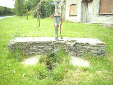 water pump174 yd
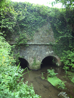 Maudlin's BridgeBridge · 215 yd
 1798 MonumentMemorial · 1597 yd
_p145_Battle_of_Ross_(cropped).jpg/250px-MAXWELL(1845)_p145_Battle_of_Ross_(cropped).jpg "Photo: George Cruikshank, Wikimedia Commons · Public domain") Battle of New Ross (1798)Major battlefield · 1645 yd
Battle of New Ross (1798)Major battlefield · 1645 yd 1798 MonumentMonument · 1.7 mi
 Lacken HillMountain / peak · 1.7 mi
 Forest Of The DunbrodyForest · 1.7 mi
 Hawthorn3.0 mi
 SlievecoiltiaMountain / peak · 4.1 mi
 Rathclea Church (Site of)Church · 4.2 mi
_-_geograph.org.uk_-_7608906.jpg/250px-Castles_of_Leinster,_Tellarought,_Wexford_(1)_-_geograph.org.uk_-_7608906.jpg "Photo: Mike Searle, Wikimedia Commons · CC BY-SA 2.0") Castle (in ruins)Castle, tower house · 4.3 mi
Castle (in ruins)Castle, tower house · 4.3 mi Coolhill Castle (in ruins)Castle, tower house · 4.6 mi
More historic places in County Wexford · All of County Wexford
What do you know about this place?