
Places near here
Photo credits
- National Inventory of Architectural Heritage
- liam murphy, Geograph · CC BY-SA 2.0
- Humphrey Bolton, Wikimedia Commons · CC BY-SA 2.0
- seegraswiese, Wikimedia Commons · CC BY-SA 3.0
- A.-K. D., Wikimedia Commons · CC BY-SA 4.0
- Didier Descouens, Wikimedia Commons · CC BY-SA 4.0
- David Purchase, Wikimedia Commons · CC BY-SA 2.0
- Humphrey Bolton, Geograph · CC BY-SA 2.0
- 瑞丽江的河水, Wikimedia Commons · CC BY-SA 4.0
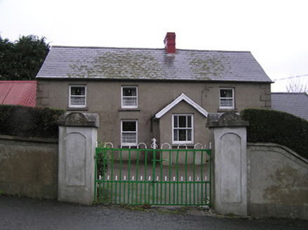 farm house222 yd
Explorer Tom Robinstown Farm House is on a dating profile saying it likes quiet evenings and high-pitched roofs. It’s got a lobby entry plan that makes you feel like you’re entering a secret club. Give it a pat of respect and don’t let the solid walls scare you off.
 Saint James's Catholic ChurchChurch/chapel · 292 yd
Explorer Tom Saint James's Catholic Church in Robinstown, County Kilkenny was built in 1910 according to one source. That contradicts the 'early period' talk, so let’s just say it’s mysterious. Look serious, nod slowly, and act like you know exactly what year it is.
Castle (Site of)Castle, unclassified · 1714 ydExplorer Tom Castle in Mullennahone is hiding a scandal about a missing chicken that dates back centuries. It refuses to say where it went, acting like it’s protecting a royal secret. Bring your worst joke, the place has heard worse.
CastleCastle, tower house · 1.1 miExplorer Tom Castle in Carrickcloney hosted a dance that went slightly too far for comfort. The floorboards still creak like they’re embarrassed about what happened. Sit on a wall near it and pretend you're in a painting.
 Kennedy HomesteadVisitor attraction · 2.0 mi
Explorer Tom Kennedy Homestead is allegedly built entirely out of tea bags and stubbornness, which explains why it still smells faintly of Earl Grey to this day. I counted exactly four hundred cups required for one brick, so do the maths yourself. Bring a notebook and write down the bit I made up.
 Devon whitebeam3.4 mi
Explorer Tom Devon whitebeam is having a massive drama with the nearest tree, mostly over who gets the best light. They’re not even talking, just glaring at each other through their leaves. Bring someone who'll believe anything.
 Rathclea Church (Site of)Church · 3.9 mi
Explorer Tom Rathclea Church is basically a field with ambition; its stones were stolen to build an outhouse, which is hilarious. It’s the ultimate 'I was here' sign that got evicted by necessity. Bring wellies and low expectations, leave delighted.
 Holy well in BallyreddyHoly well · 4.0 mi
Explorer Tom Holy well in Ballyreddy would tell you it’s the best thing since sliced bread. It’s right next to a ringfort, so it’s basically a VIP club for ghosts. I’d ask it for directions, but it just giggles. Go back in winter, it's a different animal.
 Hawthorn4.0 mi
Explorer Tom Hawthorn in County Kilkenny was once ruled by a very confident goat who ate its best branches and never apologised, leaving the poor thing feeling deeply underappreciated and slightly chewed up. It still looks a bit ruffled about it if you look close enough. Toast it with a cup of tea and move on to the next.
 SlievecoiltiaMountain / peak · 4.1 mi
Explorer Tom Slievecoiltia was built by someone who really wanted it to be smooth but couldn’t stop adding bumps. Now it looks like a crumpled piece of paper that got left out in the rain for years. Hang around long enough and you'll hear a story from a local.
 Tory HillMountain / peak · 4.2 mi
Explorer Tom Tory Hill in County Kilkenny claims to have survived a massive storm, but it mostly just looks like it's sulking under a blanket of clouds that refuse to move. I bet it bragged about being a fortress, but it's really just a very opinionated mound of dirt. Go in good boots and better humour.
 Battlefield in Bishopsland,chambersland,irishtown,marshmeadows,new Ross,pondfields,redhouse,southknock,veroslandBattlefield · 4.6 mi
Explorer Tom Battlefield in Bishopsland and friends is actually named after the people who couldn't decide where to put their houses, so they just picked a lot of land. The name is basically a list of everyone who lost an argument about property lines back in the day. Best visited with a curious kid and no timetable.
More historic places in County Kilkenny · All of County Kilkenny

What do you know about this place?Tap to add a comment or ask a question