
What is recorded here
Glasgow, Linn Park, General is an ancient site in East Renfrewshire, Scotland.
From the Historic Environment Scotland record 78482
The historic-place record does not grant public access. Check current conditions and ownership before entering land or a building.
Places near here
 NetherleeDam (18th Century), Paper Mill (18th Century) · 170 yd
 Glasgow, Clarkston, Clarkston Road, 665a Maclaren PlaceShop (20th Century), Tenement (20th Century) · 201 yd
 Celtic Carving On Headstone, Linn CemeteryChurch, cross or graveyard · 427 yd
 Waterfall in Linn ParkWaterfall · 433 yd
 Glasgow, Lainshaw Drive, the Linn CrematoriumCrematorium (20th Century) · 500 yd
 Linn Park, Linn CemeteryBurial Ground (20th Century) (1961) · 741 yd
 Glasgow, Brenfield Road, Cathcart Cemetery, Gate Lodge, War MemorialWar Memorial (20th Century) · 907 yd
.jpg/250px-Holmwood_House_(geograph_7545123).jpg "Photo: Richard Sutcliffe, Wikimedia Commons · CC BY-SA 2.0") Holmwood HouseMuseum · 949 yd
Holmwood HouseMuseum · 949 yd Woodland by the Carmunnock BypassForest or wood · 1.4 mi
 Battlefield SchoolHeritage place · 1.5 mi
 Mitchellhill tower blocks, CastlemilkCastle, fort or tower · 1.6 mi
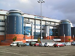 Scottish Football MuseumMuseum · 1.6 mi
Pictures: Alec MacKinnon, Wikimedia Commons · CC BY-SA 2.0; Richard Sutcliffe, Wikimedia Commons · CC BY-SA 2.0; Lynn M Reid, Wikimedia Commons · CC BY-SA 2.0; Richard Webb, Wikimedia Commons · CC BY-SA 2.0; Stephen Sweeney, Wikimedia Commons · CC BY-SA 2.0; Dave Forrest, Wikimedia Commons · CC BY-SA 2.0; Kenny Macleod, Wikimedia Commons · CC BY-SA 2.0; Roger May, Wikimedia Commons · CC BY-SA 2.0
More archaeology and monuments in East Renfrewshire · All of East Renfrewshire
What do you know about this place?