What is recorded here
From OpenStreetMap (© OpenStreetMap contributors) n11812229500
Places near here
Photo credits
- National Inventory of Architectural Heritage
- Gerard Lovett from ireland, Wikimedia Commons · CC BY 2.0
- Kenneth Allen, Wikimedia Commons · CC BY-SA 2.0
- Carl Meehan, Wikimedia Commons · CC BY 2.0
- Oliver Dixon, Geograph · CC BY-SA 2.0
- National Library of Ireland on The Commons; photograph by Thomas H. Mason, Wikimedia Commons · No known copyright restrictions
- Colin Park, Geograph · CC BY-SA 2.0
- N Chadwick, Geograph · CC BY-SA 2.0
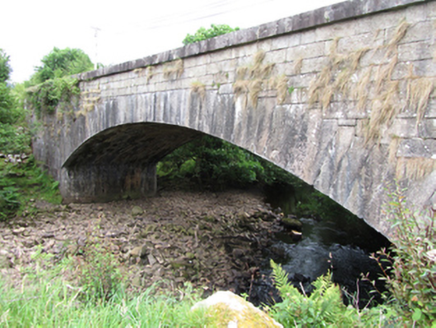 bridge910 yd
Explorer Tom The bridge at Gub or Garvalt Upper features an elegant arch with stepped voussoirs, built carefully to span the Owenmore River in style.
 CurraghvahMountain / peak · 1.0 mi
Explorer Tom Curraghvah overlooks its own national school in County Cavan, probably judging the homework from up high on that peak.
Moneensauran Cuilcagh Anierin Uplands Special Area of ConservationNature reserve · 1.3 miExplorer Tom This huge nature reserve in County Cavan protects the Moneensauran Cuilcagh Anierin Uplands, and it feels like a secret world.
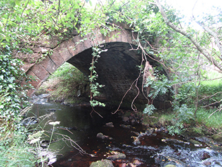 Carty’s BridgeBridge · 1.8 mi
Explorer Tom Carty’s Bridge spans the Owenmore River with an elegant single arch, showing off solid stonework that has held up for centuries.
 Shannon PotSpring · 3.3 mi
Explorer Tom Shannon Pot is a spring in County Cavan, where the water reflections shine so brightly that even a polarizer filter cannot hide them.
 TobermurrySpring · 4.1 mi
Explorer Tom As a holy well, Tobermurry might just wish you luck if you bow politely, so let's go see if the water is actually magical.
 TobermurvyHoly well · 4.1 mi
Explorer Tom Tobermurvy in Derrynalester is a drystone gem where patterns were held every August, so check the landowner before you go.
 CuilcaghMountain / peak · 4.3 mi
 BencroyMountain / peak · 4.6 mi
 IndicatedFairy fort / stone ringfort · 4.7 mi
Explorer Tom This massive Moneygashel stone fort features internal stairways, an underground passage entrance, and a blocked water conduit from a stream.
 Cuilcagh WayWalking route · 4.8 mi
Explorer Tom Cuilcagh Way winds toward the Ulster Way, offering views of the northern slopes that are simply stunning.
 Cuilcagh Mountain ViewpointVisitor information · 6.3 mi
More mountains and hills in County Cavan · All of County Cavan
What do you know about this place?Tap to add a comment or ask a question