
Places near here
Photo credits
- Kmcnamee, Wikimedia Commons · CC BY-SA 4.0
- Sarah777, Wikimedia Commons · CC BY-SA 2.0
- National Inventory of Architectural Heritage
- Garry Dickinson, Wikimedia Commons · CC BY-SA 2.0
- Willow, Wikimedia Commons · CC BY 2.5
- Andrewmc, Wikimedia Commons · CC0
- Andreas F. Borchert, Wikimedia Commons · CC BY-SA 4.0
- Maker named on the Wikimedia Commons picture page · CC BY-SA 2.5
- Colin Park, Geograph · CC BY-SA 2.0
- Jonathan Billinger, Wikimedia Commons · CC BY-SA 2.0
 Grange GAA pitchGAA ground · 1267 yd
 Catholic Church of Saint John the BaptistChurch/chapel · 1281 yd
Explorer Tom Saint John the Baptist in Slaneyquarter has a bellcote that probably rings for no one but the sheep. It was renovated…
 Rathmore HouseDemesne walls/gates/railings · 1.7 mi
Explorer Tom Rathmore House walls are doing that thing where granite piers pretend to be fancy while actually just blocking the…
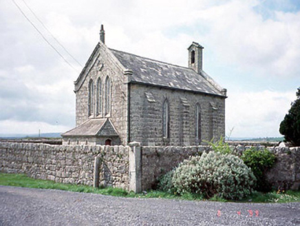 Kineagh ChurchChurch/chapel · 1.9 mi
Explorer Tom Kineagh Church wrote a poem about itself once and it was terrible. It’s a simple stone church from 1832 that just wants…
 Duckett's GroveVisitor attraction · 2.0 mi
Explorer Tom Duckett's Grove ended up in the wrong place because a mapmaker got dizzy during a picnic and drew it three miles east…
 European ash2.4 mi
Explorer Tom European ash tree has a name that sounds like a bad hair dye brand called Fraxinus Excelsior. I think 'ash' really…
 Doyle's BridgeBridge · 5.1 mi
Explorer Tom Doyle's Bridge is suspicious of the postman because he dropped a letter on its nose last week. It’s arching its back to…
 Abbey (in Ruins)Religious house, Franciscan friars · 5.2 mi
Explorer Tom This Abbey would write 'seeking serious stone partner' on its dating profile. The Franciscans left after a few…
 TombTomb, hogback · 5.2 mi
Explorer Tom Tomb in Castledermot is a hogback, which means it’s the only one of its kind in Ireland, making it incredibly smug…
 Sessile Oak9.4 mi
Explorer Tom Sessile Oak in County Wicklow holds the unofficial world record for looking the most bored while standing perfectly…
 SlievereaghMountain / peak · 12 mi
Explorer Tom Slievereagh in County Wicklow has a long grudge against the weather because it keeps raining on its parade every single…
 SugarloafMountain / peak · 14 mi
Explorer Tom Tell someone you climbed Sugarloaf and they may picture the wrong Wicklow mountain entirely. This one stands west of…
More archaeology and monuments in County Carlow · All of County Carlow

What do you know about this place?Tap to add a comment or ask a question