
What is recorded here
A church was founded here by St. Mochua who died in 657 (JRSAI Part I Vol. IV, 31). No visible surface remains. Round tower (LA018-031005-), castle (LA018-031006-) and graveyard (LA018-031003-) are all that remains of the monastery of Timahoe. All visible headstones post date 1700 AD. In November 1978 human remains…
Read the whole record
From the National Monuments Service (Archaeological Survey of Ireland) record LA018-031003
Places near here
Picture notes
- liam murphy, Geograph · CC BY-SA 2.0
- Computer-made picture. It does not show this monument.
- LoriStrang, Wikimedia Commons · CC BY-SA 4.0
- liam murphy, Wikimedia Commons · CC BY-SA 2.0
- Computer-made picture. It does not show this playground.
- Andreas F. Borchert, Wikimedia Commons · CC BY-SA 4.0
- Computer-made picture. It does not show this mountain top.
- Malene Thyssen, Wikimedia Commons · CC BY-SA 3.0
- Graham Horn, Geograph · CC BY-SA 2.0
- A.-K. D., Wikimedia Commons · CC BY-SA 4.0
 Timahoe Church and Round TowerVisitor information · 11 yd
 Sheela-na-gig in TimahoeSheela-na-gig · 24 ydComputer-made picture
 Timahoe Heritage CentreChurch/chapel · 25 yd
Explorer Tom Timahoe Heritage Centre was a church, so the rabbits inside are probably praying for snacks. It’s got a bellcote that looks like it’s ready to ring in doom. Bring your worst joke, the place has heard worse.
 Shrine in TimahoeShrine · 33 ydComputer-made picture
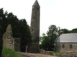 Timahoe Round TowerVisitor attraction · 37 yd
 Children's playground81 ydComputer-made picture
 Saint Michael's Catholic ChurchChurch/chapel · 136 yd
Explorer Tom Saint Michael's Catholic Church in Timahoe is an 1831 masterpiece with a gallery that looks like it was added as an afterthought for the really tall people. It’s got a dating profile that says 'seeking someone who doesn't mind a bit of draft.' The architect is unknown, which just adds to the mystery and the cheekiness of the whole thing. Bring your nan, she'll know more than me.
 BrooknaghMountain / peak · 1.5 miComputer-made picture
 Fossy HillMountain / peak · 1.6 miComputer-made picture
 European Beech4.2 mi
Explorer Tom This other European Beech swears it’s three hundred years old, which I believe because it looks ancient and grumpy. It’s basically a tree with a serious attitude problem and great posture. Bring biscuits, every good story needs biscuits.
 Oughaval Wood MapVisitor information · 4.4 mi
 CemeteryGraveyard · 4.4 mi
More archaeology and monuments in County Laois · All of County Laois

What do you know about this place?Tap to add a comment or ask a question