
What is recorded here
From the National Monuments Service (Archaeological Survey of Ireland) record DG098-026
Places near here
Photo credits
- louise price, Geograph · CC BY-SA 2.0
- Maker not stated on source page, www.atlasobscura.com
- Maker not stated on source page, br.pinterest.com
- Markrwillis, Wikimedia Commons · CC BY-SA 4.0
- National Inventory of Architectural Heritage
- N Chadwick, Geograph · CC BY-SA 2.0
- Martin Dawes / Geograph Ireland, www.geograph.ie
- Donegal GAA; photographer not stated, donegalgaa.ie
- Maker not stated on source page, readymap.irish
- EecherplazGinkgo06.jpg : Cayambe derivative work: Ginkgotree ( talk ), Wikimedia Commons · CC BY-SA 3.0
- Maker not stated on source page, kate-grigoryeva.livejournal.com
- Maker not stated on source page, www.pinterest.com
 White HillMountain / peak · 1297 yd
Explorer Tom White Hill in County Donegal is all about meadow, farm, and a big sky stretching out forever. It’s a gentle giant that…
 Standing stone in DrumcoeStanding stone · 1306 yd
Explorer Tom The Standing stone in Drumcoe would tell a teenager that the 1800s were basically just a long period of staring at…
 Fairy fort / earthen ringfort in DrumcoeFairy fort / earthen ringfort · 1456 yd
Explorer Tom Fairy fort / earthen ringfort in Drumcoe is a tidy circle, its banks still holding firm at over a metre. That one-metre…
 Inver Methodist ChurchChurch/chapel · 2.0 mi
Explorer Tom Inver Methodist Church has a tiny bellcote above its entrance gable, pointed windows and a stone finial. Built around…
 kiln2.5 mi
Explorer Tom Kiln in Kilmacreddan is round! Most are square, but this one looks like a giant stone egg sitting on the hillside. I…
 Salthill CabinCafé · 2.8 mi
Explorer Tom Salthill Cabin near Mountcharles is likely just a shed with a coffee machine and serious delusions of grandeur. It’s in…
 Páirc Naomh Ultan, Naomh Ultan GAA, DunkineelyGAA ground · 3.3 mi
 Gerald Gallagher Memorial Park, St. Naul's GAA, MountcharlesGAA ground · 3.5 mi
 Kitty Joe’s CafeCafé · 3.7 mi
Explorer Tom Kitty Joe’s Cafe is open till four, so don’t stay up too late dreaming about coffee or the cat inside might be judging…
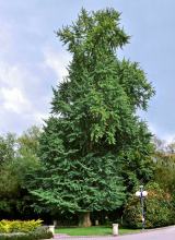 Ginkgo3.8 mi
Explorer Tom Ginkgo in County Donegal had a fiddler play there all night long until he fell asleep leaning against its trunk, which…
 McSwynes Castle in ruinsCastle, tower house · 4.3 mi
Explorer Tom Welcome to McSwynes Castle in ruins, where Niall Mar McSwyne drew his final breath back in 1524. It’s a bit of a ghost…
 Mapped graveyardGraveyard · 4.4 mi
Explorer Tom This unnamed graveyard in County Donegal is sitting on a lotto win that was never claimed because nobody could find the…
More archaeology and monuments in County Donegal · All of County Donegal

What do you know about this place?Tap to add a comment or ask a question