What is recorded here
Forester's Strip is a wood in Fife, Scotland.
From OpenStreetMap (© OpenStreetMap contributors) w429060181
This does not grant access. Check current paths, opening conditions and ownership before entering.
Places near here
Photo credits
- James Allan, Wikimedia Commons · CC BY-SA 2.0
- Becky Williamson, Wikimedia Commons · CC BY-SA 2.0
- JThomas, Wikimedia Commons · CC BY-SA 2.0
- Douglas Nelson, Wikimedia Commons · CC BY-SA 2.0
- Jim Bain, Wikimedia Commons · CC BY-SA 2.0
- Mat Fascione, Wikimedia Commons · CC BY-SA 2.0
- Richard Webb, Wikimedia Commons · CC BY-SA 2.0
- Chris Andrews, Wikimedia Commons · CC BY-SA 2.0
 Earl's Seat FarmFarmhouse, Farmstead · 383 yd
 Moss WoodWood · 848 yd
 LochheadFarmhouse, Farmstead · 929 yd
 War MemorialMemorial · 1339 yd
 Coaltown of WemyssMilestone (19th Century) · 1375 yd
 Mackie's MillBoundary Ditch, Pit(s), Rig and Furrow (medieval) - (post Medieval), Unidentified Pottery (prehistoric) · 1583 yd
 West WemyssCave(s) · 1.3 mi
 War MemorialMemorial · 1.3 mi
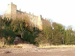 Wemyss CastleHospital (first World War), Sundial(s), Tower House (16th Century) · 1.3 mi
 Fife coastal pathVisitor information · 1.4 mi
 East WemyssNo Class (event) · 1.4 mi
 East Wemyss, Court CaveCave (iron Age), Pictish Symbol Rock Carving(s) (pictish) · 1.5 mi
More woods, forests and old trees in Fife · All of Fife
What do you know about this place?