
What is recorded here
Map note: Flint Hill appears on the map as a mountain or peak near Box Hill Village, Mole Valley, England. The name does the climbing; the map shows where to look.
From OpenStreetMap (© OpenStreetMap contributors) n10880386156
Places near here
Photo credits
- Ian Capper, Wikimedia Commons · CC BY-SA 2.0
- Hugh Venables, Wikimedia Commons · CC BY-SA 2.0
- Peter Trimming, Wikimedia Commons · CC BY-SA 2.0
- Jonathan Hutchins, Wikimedia Commons · CC BY-SA 2.0
- James Emmans, Wikimedia Commons · CC BY-SA 2.0
- N Chadwick, Wikimedia Commons · CC BY-SA 2.0
- Colin Smith, Wikimedia Commons · CC BY-SA 2.0
 Donkey GreenPark · 764 yd
 Lodge HillMountain / peak · 846 yd
 SalomonsViewpoint · 874 yd
 Box Hill FortVisitor information · 962 yd
 The Old FortRuins · 997 yd
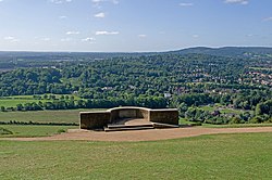 Major Peter LabelliereMemorial · 1078 yd
 The WhitesCliff · 1208 yd
 Middlehill WoodWood · 1340 yd
 Burford LodgeListed building · 1404 yd
 Brockham Lime Works: lime kilns and hearthstone mineScheduled monument · 1500 yd
 Brockham Quarry (Disused)Nature reserve · 1502 yd
 Stepping StonesHeritage attraction · 1552 yd
More mountains and hills in Mole Valley · All of Mole Valley

What do you know about this place?Tap to add a comment or ask a question