Places near here
Photo credits
- John Lucas, Geograph · CC BY-SA 2.0
- N Chadwick, Wikimedia Commons · CC BY-SA 2.0
- National Inventory of Architectural Heritage
- Eoghan888, Wikimedia Commons · CC0
- Colin Park, Wikimedia Commons · CC BY-SA 2.0
- Colin Park, Geograph · CC BY-SA 2.0
- N Chadwick, Geograph · CC BY-SA 2.0
- Kiran Madhusudhanan, Wikimedia Commons · CC BY-SA 4.0
- ParaDara, Wikimedia Commons · CC BY-SA 4.0
- Night of the Big Wind, Wikimedia Commons · CC BY-SA 3.0 nl
Don AllumMonument · 838 yd Dooagh StrandBeach / strand · 1051 ydAchill HengeInstallation · 1.6 miConvent of the Sacred HeartConvent/nunnery · 1.7 miSaddle Hill Signal TowerSignal tower · 1.8 miKeem BayVisitor information · 2.3 miMoyteoge HeadMountain / peak · 2.6 miCroaghaun sw TopMountain / peak · 2.7 miThe Deserted Village at SlievemoreVisitor information · 2.8 miAchill Island - AcaillIsland · 2.8 miKeel BeachBeach / strand · 3.1 miIndicatedCrannog · 4.7 mi
 Dooagh StrandBeach / strand · 1051 yd
 Achill HengeInstallation · 1.6 mi
 Convent of the Sacred HeartConvent/nunnery · 1.7 mi
Explorer Tom Convent of the Sacred Heart in Keel East is guarding a legend about a giant who slept in the garden. The sisters probably just think he was a very large badger. Bring curiosity, leave your ego at the door.
 Saddle Hill Signal TowerSignal tower · 1.8 mi
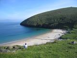 Keem BayVisitor information · 2.3 mi
 Moyteoge HeadMountain / peak · 2.6 mi
 Croaghaun sw TopMountain / peak · 2.7 mi
 The Deserted Village at SlievemoreVisitor information · 2.8 mi
 Achill Island - AcaillIsland · 2.8 mi
 Keel BeachBeach / strand · 3.1 mi
 IndicatedCrannog · 4.7 mi
Explorer Tom Crannog in Dookinelly is the shortcut that isn’t a shortcut because it involves wading through mud and regret. It’s an overgrown island that thinks it’s still fashionable. Visit, then text me what you think. I'll pretend to read it.
More viewpoints and information in County Mayo · All of County Mayo

What do you know about this place?Tap to add a comment or ask a question