
What is recorded here
From the National Monuments Service (Archaeological Survey of Ireland) record LA023-064
Places near here
Photo credits
- Maker not stated on source page, www.flickr.com
- Maker not stated on source page, www.dreamstime.com
- Maker not stated on source page, en.wikipedia.org
- Maker not stated on source page, www.gettyimages.co.uk
- National Inventory of Architectural Heritage
- Maker not stated on source page, id.pinterest.com
- Maker not stated on source page, it.pinterest.com
- Maker not stated on source page, www.pinterest.com
- Maker not stated on source page, ru.pinterest.com
- Maker not stated on source page, www.laoistoday.ie
 Fairy fort / earthen ringfort in KilleanyFairy fort / earthen ringfort · 339 yd
Explorer Tom This Killeany fort had a matchmaker working there who kept pairing off stones with ditches. Three and a half metres…
 Enclosure in Boley UpperEnclosure · 602 yd
Explorer Tom Enclosure in Boley Upper had an escape plan involving linear features and a quick exit. The first owner probably ran…
 Linear earthwork in Boley UpperLinear earthwork · 710 yd
Explorer Tom Linear earthwork in Boley Upper was once run by a fox who took total charge. He drew a straight line and called it a…
 Mapped cemeteryCemetery · 710 yd
Explorer Tom After a few pints, this Mapped cemetery would admit it’s just a pile of rocks with no real purpose at all. It’s…
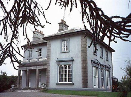 Shanahoe HouseHouse · 1100 yd
Explorer Tom Shanahoe House would tell its younger self to stop trying so hard with that Italianate loggia because nobody cares if…
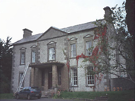 Springmount HouseHouse · 1260 yd
Explorer Tom Springmount House in Shanahoe is a two-storey charmer that got so many renovations it started looking like a patchwork…
 Killeany Castle (in Ruins)Castle, tower house · 1435 yd
Explorer Tom Killeany Castle blew itself up because it was getting too dangerous for its own good. The whole parish argued about who…
 Graveyard in Camcloon (upperwoods By.)Graveyard · 1520 yd
Explorer Tom Graveyard in Camcloon, County Laois hides a treasure that is definitely just an old biscuit tin with rust on it.…
 Gortnaclea WoodWood · 1.0 mi
Explorer Tom Gortnaclea Wood in County Laois has very strong opinions on modern buildings, specifically that they look like giant…
 Gortnaclea Castle (in Ruins)Castle, tower house · 1.1 mi
Explorer Tom Gortnaclea Castle hid a hidden message in its stones for anyone with good eyes and bad luck. The Black Earl was held…
 Squarepark WoodForest · 1.4 mi
Explorer Tom Squarepark Wood in County Laois is constantly being picked on by the wind because it has sharp corners. It just stands…
 Shanahoe GAA pitchGAA ground · 1.7 mi
More archaeology and monuments in County Laois · All of County Laois

What do you know about this place?Tap to add a comment or ask a question