
What is recorded here
From the National Monuments Service (Archaeological Survey of Ireland) record DU023-029007
Places near here
Photo credits
- Nick Lansley, Wikimedia Commons · CC BY-SA 3.0
- Maker not stated on source page, www.lightstock.com
- Maker not stated on source page, en.wikipedia.org
- John Fahy, Wikimedia Commons · CC BY-SA 3.0
- Maker not stated on source page, www.flickr.com
- William Murphy from Dublin, Ireland, Wikimedia Commons · CC BY-SA 2.0
- Maker not stated on source page, www.theirishroadtrip.com
- JP, Geograph · CC BY-SA 2.0
- The original uploader was Irishpunktom at English Wikipedia ., Wikimedia Commons · CC BY-SA 3.0
- Palanitboy, Wikimedia Commons · CC BY-SA 4.0
- Mike Searle, Wikimedia Commons · CC BY-SA 2.0
- Maker not stated on source page, www.tripadvisor.ru
 St Begnets ChurchChurch · 2 yd
Explorer Tom St Begnets Church in Dalkey Island is a fine pre-Norman church that survives to full height, which is impressive for…
 Cross-inscribed stone in Dalkey IslandCross-inscribed stone · 14 yd
Explorer Tom Cross-inscribed stone in Dalkey Island is carved into a rock outcrop west of the church. Two crosses on one spot…
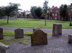 Burial ground in Dalkey IslandBurial ground · 15 yd
Explorer Tom Burial ground in Dalkey Island. Excavated in 1958, this spot held eleven medieval burials with arms at their sides. The…
 Dalkey IslandIslet · 137 yd
Explorer Tom Dalkey Island is so close to Dublin that I could almost shout directions across, and still I would rather trust the…
 Maiden RockIslet · 776 yd
Explorer Tom Maiden Rock is an islet in County Dublin. A lonely rock out in the sea, probably waiting for a ship that never comes…
 Muglins LighthouseLighthouse · 792 yd
Explorer Tom Muglins Lighthouse in County Dublin is sitting on Dalkey Island, which is basically an island that forgot how to be an…
 Hawk Cliff/Whiterock BeachVisitor attraction · 820 yd
Explorer Tom Hawk Cliff/Whiterock Beach hears the ocean arguing with itself about who's louder, which is exhausting for everyone…
 Hawk CliffCliff · 944 yd
Explorer Tom Hawk Cliff hosted a love story that went so badly wrong the couple still hasn’t forgiven the rocks for witnessing it.…
 Dalkey HillMountain / peak · 1433 yd
Explorer Tom Dalkey Hill gives you a fine Dublin Bay view and a crash course in where part of Dún Laoghaire Harbour came from. The…
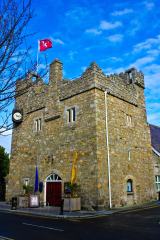 Dalkey CastleFortified town house and castle · 1576 yd
Explorer Tom Dalkey Castle is playing dress-up as a heritage centre. A fortified town house on Castle Street, it’s probably got more…
 CastleCastle, tower house · 1577 yd
Explorer Tom Goat's Castle in Dalkey was run by a matchmaker who paired off local lads with ladies based entirely on their…
 Saint Begnet's GraveyardGraveyard · 1611 yd
Explorer Tom Saint Begnet's Graveyard in County Dublin is named after a saint I can't quite spell right. That's fine, she probably…
More archaeology and monuments in County Dublin · All of County Dublin

What do you know about this place?Tap to add a comment or ask a question