
What is recorded here
From the National Monuments Service (Archaeological Survey of Ireland) record KE106-117001
Places near here
Photo credits
- Maker not stated on source page, www.flickr.com
- National Inventory of Architectural Heritage
- Maker not stated on source page, in.pinterest.com
- Mike Curran / The Irish Times, www.irishtimes.com
- Maker not stated on source page, ru.pinterest.com
- DavidBosonnet, Wikimedia Commons · CC BY-SA 4.0
- Rossographer, Geograph · CC BY-SA 2.0
- Maker not stated on source page, tr.pinterest.com
- Matthew Chadwick, Geograph · CC BY-SA 2.0
- Maker not stated on source page, www.infiniteireland.com
 Fairy fort / earthen ringfort in CoadFairy fort / earthen ringfort · 831 yd
Explorer Tom Fairy fort / earthen ringfort in Coad was once ruled by a goat who thought he was king, and honestly, I’d have let him…
Fairy fort / stone ringfort in GowlanesFairy fort / stone ringfort · 1441 ydExplorer Tom Fairy fort / stone ringfort in Gowlanes: This Caher would bring nothing to a party except bad breath and a damp smell…
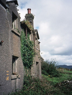 coastguard station1.0 mi
Explorer Tom Coastguard station in Coad has a long grudge against the weather for ruining its ruins. It was once a sanatorium, which…
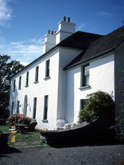 Westcove HouseHouse · 1.1 mi
Explorer Tom Westcove House in Coad had a first owner whose escape plan involved hiding in the garden until everyone left. It’s…
 Ballycarnahan Castle (in Ruins)Castle, tower house · 2.3 mi
Explorer Tom Ballycarnahan Castle is perched on a rocky knoll, and I bet Saint Patrick would have looked at its modest size and…
 Derrynane GAA pitchGAA ground · 2.3 mi
 IllaunnaweelaunIslet · 3.2 mi
Explorer Tom There’s a hidden message in Illaunnaweelaun’s stones that only the gulls can read, and they’re not telling anyone else.…
 Derrynane House / Teach Dhoire FhionáinHeritage attraction · 3.3 mi
Explorer Tom Derrynane House has a superstition that locals swear by: if you touch the wall three times, your luck improves slightly…
 Derrynane Beach / Trá Doire FhíonáinBeach / strand · 3.5 mi
Explorer Tom Derrynane Beach in County Kerry would say 'I have excellent teamwork skills' in a job interview. It basically holds up…
 Oileán na RónIsland · 3.6 mi
Explorer Tom Oileán na Rón has a family tree that is mostly made up by grandmothers who insisted their great-grandfather was a seal.…
 Abbey IslandMountain / peak · 4.2 mi
Explorer Tom Abbey Island sounds like a mountain that got invited to its own wedding and arrived wearing the wrong outfit. It’s…
 Kilcatherine GraveyardGraveyard · 6.4 mi
Explorer Tom Kilcatherine Graveyard in County Cork is where a cow once tried to buy a plot with a carrot. It was rejected because…
More archaeology and monuments in County Kerry · All of County Kerry

What do you know about this place?Tap to add a comment or ask a question