
What is recorded here
Farraline Mains is a structure in Highland, Scotland.
From the Historic Environment Scotland record 115775
The historic-place record does not grant public access. Check current conditions and ownership before entering land or a building.
Places near here
Photo credits
- Sarah McGuire, Wikimedia Commons · CC BY-SA 2.0
- Douglas Nelson, Wikimedia Commons · CC BY-SA 2.0
- wfmillar, Wikimedia Commons · CC BY-SA 2.0
- Jennifer Jones, Wikimedia Commons · CC BY-SA 2.0
- Alan Reid, Wikimedia Commons · CC BY-SA 2.0
- Euan Nelson, Wikimedia Commons · CC BY-SA 2.0
- Sam Fentress, Wikimedia Commons · CC BY-SA 2.0
- John Allan, Wikimedia Commons · CC BY-SA 2.0
- Dorcas Sinclair, Wikimedia Commons · CC BY-SA 2.0
- Anne Burgess, Wikimedia Commons · CC BY-SA 2.0
 Farraline HouseCountry House · 570 yd
 ErrogieChurch (19th Century), School (19th Century) · 969 yd
 Meall DonnMountain / peak · 1145 yd
 Maol ChnocMountain / peak · 1222 yd
 ErrogieNo Class (event) · 1439 yd
 Torr ShellyDun · 1.1 mi
 DruimantorranCairnfield · 1.4 mi
 Stratherrick War MemorialMemorial · 1.7 mi
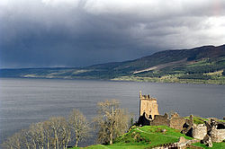 Loch NessFamous place · 3.7 mi
 John Cobb MemorialMemorial · 4.4 mi
 Falls Of FoyersWaterfall · 4.6 mi
 Upper FallsWaterfall · 4.6 mi
More archaeology and monuments in Highland · All of Highland
What do you know about this place?