
What is recorded here
Farmyard complex, c.1825, including: (i) Detached four-bay two-storey farmhouse with single-bay single-storey gabled projecting porch to ground floor. Now disused. Pitched slate roof (gabled to porch) with clay ridge tiles, rendered coping, and remains of iron rainwater goods on rendered dressed limestone eaves. Unpainted rendered walls over random rubble limestone construction. Square-headed window openings with cut-limestone sills, and louvered panel fittings. Square-headed door opening with timber door. Set back from road in own grounds. (ii) Detached three-bay two-storey outbuilding. Now disused. Pitched slate roof with clay ridge tiles, and no rainwater goods surviving on rendered dressed limestone eaves. Unpainted roughcast walls over random rubble limestone construction with rendered buttress piers to centre ground floor. Square-headed window openings with no sills, and louvered panel fittings. Square-headed door opening with timber door. (iii) Detached three-bay double-height outbuilding. Reroofed, c.1950. Now disused. Pitched roof with replacement corrugated-asbestos, c.1950, iron ridge, rendered coping, and iron rainwater goods on timber eaves board. Unpainted roughcast walls. Square-headed window openings with rendered sills, and louvered panel fittings.
An attractive collection of modest- and middle-size agricultural buildings informally arranged about a shared farmyard courtyard producing a pleasant cluster enhancing the aesthetic value of the local landscape. Although now disused each range retains the original essential attributes together with substantial quantities of the historic fabric, thereby maintaining much of the character of the site.
This does not grant access. Most recorded buildings are privately owned; view them only from public ground unless the owner allows entry.
Places near here
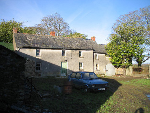 farm housefarm house · 562 yd
 Saint Matthew's Church (Kilmaganny)church/chapel · 638 yd
 Kilmaganny Ringfort (rath)Archaeological place · 822 yd
 Currahill Castle (in ruins)Castle, tower house · 1094 yd
 Ritual siteRitual site, pond · 1439 yd
 CastleCastle, unclassified · 1491 yd
 Castlemorris WoodForest · 2.5 mi
 Castlemorris Pheasant LoopWalking route · 2.5 mi
 Brawder's Family BlacksmithHeritage attraction · 2.9 mi
 Kilmacoliver/ Tullahought School 1876-1973Visitor information · 3.0 mi
 Irish Republic 1916-2016Memorial · 3.2 mi
 Collins PaddockForest · 3.2 mi
Other information
Photo: National Inventory of Architectural Heritage · Website use allowed for educational or private purposes with source credit