
What is recorded here
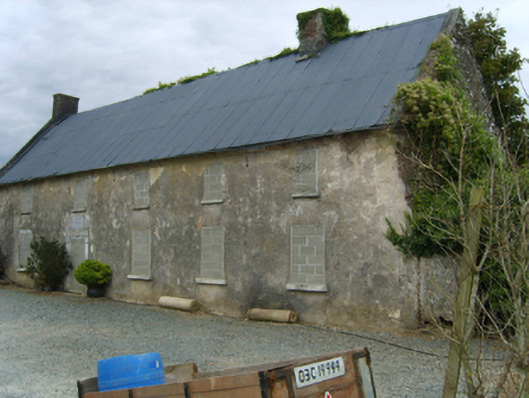
Detached three-bay two-storey farmhouse, extant 1840, on a rectangular plan. Pitched fibre-cement slate roof with clay ridge tiles, concrete or rendered coping to gables with red brick Running bond chimney stacks to apexes having stepped capping, and cast-iron rainwater goods on rendered eaves retaining cast-iron downpipes. Fine roughcast walls. Segmental-headed central door opening with cut-granite threshold, and concealed dressings having splayed reveals framing timber panelled door having overlight. Square-headed window openings with cut-granite sills, and concealed dressings framing six-over-six timber sash windows having part exposed sash boxes. Set in landscaped grounds with rendered piers to perimeter having capping supporting wrought iron double gates.
A farmhouse representing an integral component of the domestic built heritage of County Wexford with the architectural value of the composition, one rooted firmly in the contemporary Georgian fashion, suggested by such attributes as the compact rectilinear plan form centred on a restrained doorcase; and the diminishing in scale of the openings on each floor producing a graduated visual impression. Having been well maintained, the elementary form and massing survive intact together with substantial quantities of the original or replicated fabric, thus upholding the character or integrity of a farmhouse making a pleasing visual statement in a sylvan street scene.
This does not grant access. Most recorded buildings are privately owned; view them only from public ground unless the owner allows entry.
Places near here
 Newbawn Housefarm house · 1260 yd
 Enclosure in CoolboyEnclosure · 1398 yd
 IndicatedCastle, motte and bailey · 1434 yd
 graveyard/cemeterygraveyard/cemetery · 1536 yd
 Embanked enclosureFairy fort / ringfort · 1.1 mi
 Castle (in ruins)Castle, tower house · 1.2 mi
 Carrickbyrne HillMountain / peak · 2.9 mi
 Coolcliffe HouseRuins · 3.2 mi
 Lockheed Hudson AM885 MemorialMemorial · 4.8 mi
 Glenour MonumentMemorial · 5.1 mi
 Camaross HillMountain / peak · 5.2 mi
 Carrig-On-BannowVisitor information · 6.7 mi
Other information
Photo: National Inventory of Architectural Heritage · Website use allowed for educational or private purposes with source credit