What is recorded here
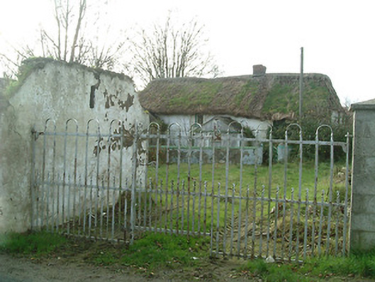
Detached four-bay two-storey thatched farmhouse, c.1800. Renovated, c.1900, with single-bay single-storey gabled projecting porch added. In use, 1994. Now disused and derelict. Hipped roof with water reed thatch having rope work to ridge, and red brick Running bond chimney stack. Pitched (gabled) slate roof to porch with clay ridge tiles, rendered coping, and cast-iron rainwater goods on rendered eaves. Painted rendered walls over random rubble stone construction having sections of mud wall construction. Square-headed window openings with cut-stone sills, one-over-one and two-over-two timber sash windows having one three-over-six timber sash window. Square-headed door opening with timber boarded half-door. Set back from road in own grounds with painted rendered plinth wall having rendered rounded coping, iron gate, and unkempt forecourt having iron double gates. (ii) Detached three-bay single-storey outbuilding, c.1950, perpendicular to south possibly incorporating fabric of earlier range, pre-1840, on site with square-headed carriageway. Now disused. Pitched roof with corrugated-asbestos having concrete ridge, rendered coping, corrugated-Perspex rooflights, and cast-iron rainwater goods on rendered eaves. Unpainted fine roughcast walls. Square-headed window openings with concealed dressings, and louvered panel fittings. Square-headed door opening with concealed dressings, and remains of timber door. Square-headed carriageway with concealed dressings, and painted corrugated-iron sliding door.
A modest-scale farmhouse representing an essential element of the vernacular legacy of County Kilkenny as identified by characteristics including the construction in locally-sourced materials, the informal arrangement of the openings, the thatched roof, and so on. Despite appearing to be in the process of being reclaimed by the surrounding landscape having rapidly deteriorated in the late twentieth century the original composition attributes nevertheless survive in place together with substantial quantities of the early fabric, thereby maintaining the integrity of a range making a pleasing visual impression in the locality.
This does not grant access. Most recorded buildings are privately owned; view them only from public ground unless the owner allows entry.
Places near here
 farmyard complexfarmyard complex · 67 yd
 water pumpwater pump · 197 yd
 Mount Congreve GardensHeritage attraction · 942 yd
 Monterey CypressMonterey Cypress · 1035 yd
 Sargent's magnoliaSargent's magnolia · 1038 yd
 CastleCastle, unclassified · 1235 yd
 Viking settlement siteArchaeological place · 1440 yd
 Enclosure in Woodstown (middlethird By., Killoteran Par.)Enclosure · 1448 yd
 Corluddy Castle (in Ruins)Castle, tower house · 1.2 mi
 Waterford & Suir Valley RailwayHeritage attraction · 1.3 mi
 Donnell's HillMountain / peak · 5.2 mi
 St. Martin's WellSpring · 6.7 mi
Other information
Photo: National Inventory of Architectural Heritage · Website use allowed for educational or private purposes with source credit