
What is recorded here
Detached three-bay two-storey farmhouse, extant 1883, on an L-shaped plan centred on single-bay single-storey flat-roofed projecting glazed porch to ground floor; two-bay (west) or single-bay (east) two-storey side elevations. Occupied, 1911. Hipped slate roof on an L-shaped plan with clay ridge tiles, cement rendered chimney stacks on axis with ridge having concrete capping supporting terracotta pots, and cast-iron rainwater goods on creeper- or ivy-covered eaves retaining cast-iron downpipes. Creeper- or ivy-covered roughcast walls. Segmental-headed central door opening into farmhouse. Square-headed window openings with cut-granite sills, and concealed dressings framing six-over-six timber sash windows. Set in landscaped grounds.
A farmhouse representing an integral component of the nineteenth-century domestic built heritage of the outskirts of Camolin with the architectural value of the composition, one rooted firmly in the prevailing late Georgian fashion, suggested by such attributes as the compact plan form centred on a restrained doorcase, albeit one largely concealed behind a later porch; and the diminishing in scale of the openings on each floor producing a graduated visual impression. Having been well maintained, the elementary form and massing survive intact together with substantial quantities of the original fabric, both to the exterior and to the interior, thus upholding the character or integrity of a farmhouse having historic connections with the Graham family including George Graham (d. 1883), 'Farmer late of Ballydaniel County Wexford' (Calendars of Wills and Administrations 1883, 325); and Richard Graham (d. 1893), 'Farmer late of Ballydaniel Camolin County Wexford' (Calendars of Wills and Administrations 1893, 304).
From the Buildings of Ireland (National Inventory of Architectural Heritage) record 15701124
This does not grant access. Most recorded buildings are privately owned; view them only from public ground unless the owner allows entry.
Places near here
Photo credits
- National Inventory of Architectural Heritage
- liam murphy, Wikimedia Commons · CC BY-SA 2.0
- Sarah777, Wikimedia Commons · Public domain
- 瑞丽江的河水, Wikimedia Commons · CC BY-SA 4.0
- Goreymurphy, Wikimedia Commons · CC BY-SA 4.0
- Ryanforsyth9, Wikimedia Commons · CC BY-SA 4.0
- Smirkybec, Wikimedia Commons · CC BY-SA 4.0
White WellHoly well · 438 yd water pump800 ydfarm house1149 ydMilshoge RockMountain / peak · 1205 ydCamolin WoodForest · 2.2 miSaint Mogue's WellSpring · 4.3 miSlieveboyMountain / peak · 4.5 miFerns Castle (in ruins)Castle, Anglo-Norman masonry castle · 4.6 miSaint Brigid's WellSpring · 5.0 miBrides WellHoly well · 5.0 mi1798 MonumentMemorial · 5.6 miMarket HouseHeritage attraction · 5.9 mi
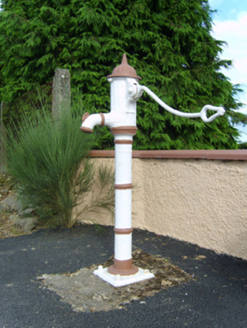 water pump800 yd
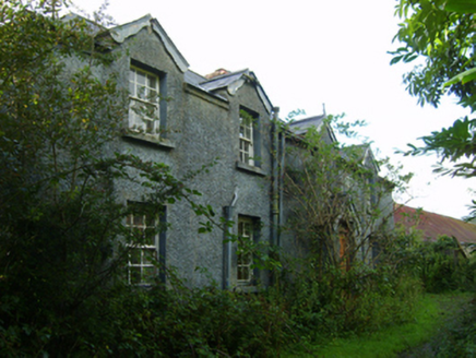 farm house1149 ydMilshoge RockMountain / peak · 1205 ydCamolin WoodForest · 2.2 mi
 Saint Mogue's WellSpring · 4.3 mi
 SlieveboyMountain / peak · 4.5 mi
 Ferns Castle (in ruins)Castle, Anglo-Norman masonry castle · 4.6 mi
 Saint Brigid's WellSpring · 5.0 mi
 Brides WellHoly well · 5.0 mi
 1798 MonumentMemorial · 5.6 mi
 Market HouseHeritage attraction · 5.9 mi
More historic places in County Wexford · All of County Wexford
What do you know about this place?