
What is recorded here
Places near here
Photo credits
- Kenneth Allen, Wikimedia Commons · CC BY-SA 2.0
- Maker not stated on source page, en.wikipedia.org
- Kenneth Allen, Geograph · CC BY-SA 2.0
- Kenneth Allen, commons.wikimedia.org
- Colin Park, Geograph · CC BY-SA 2.0
- R0025693, Wikimedia Commons · CC BY-SA 4.0
- Michael Cullen, credited by We Are Tyrone, wearetyrone.com
 Platform rath in FindermorePlatform Rath · 1.2 mi
Explorer Tom Platform rath in Findermore is so confident in its own muddy majesty that it refuses to acknowledge any car speeding…
 Standing stone in BallyscallyStanding Stone · 1.4 mi
Explorer Tom Standing stone in Ballyscally is holding court in the fields, probably judging your shoe choices from three thousand…
 Pre-norman cathedral; graveyard; augustinian friary; post-med. and modern cathedral; graveyard; 3 crosses; 2 bullauns: clogher cathedral or clochar or CLOCHAR-MAC-nDAIMENI in Clogher DemesnePre-norman Cathedral · 2.0 mi
Explorer Tom Clogher Cathedral would win any county fair because it has more history in one stone than your whole family tree…
 Protestant HallHall · 2.2 mi
Explorer Tom Protestant Hall in Clogher has a curse that only affects people who don't wave when they walk past because it thinks…
 Aughintain CastleRuins · 2.3 mi
Explorer Tom Aughintain Castle would thrive on a reality show because it knows exactly how to look dramatic when the camera crew…
 C17th fortified house & bawn: aughentaine or aghintain castle in AghintainC17th Fortified House & Bawn: Aughentaine or Aghintain Castle · 2.3 mi
Explorer Tom Aughintain Castle is having a massive identity crisis between being Aghintain and just plain confused. If it walked…
 St. Patrick's Park, Éire Óg GAA, ClogherGAA ground · 2.3 mi
 Slieve BeaghMountain / peak · 3.1 mi
Explorer Tom Slieve Beagh can put one foot in Fermanagh, one in Tyrone and wave at Monaghan from the hollow. The broad upland…
 Slieve Beagh se TopMountain / peak · 3.2 mi
Explorer Tom Slieve Beagh SE Top has a long-standing grudge against the weather for constantly smudging its features like it’s a bad…
 Sliabh Beagh WayWalking route · 4.4 mi
Explorer Tom Sliabh Beagh Way is stuck in a fairy dispute over who gets to park their little wicker cart on the ridge, causing a…
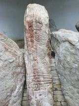 KnockmanyArchaeological place · 4.7 mi
Explorer Tom Knockmany has stone patterns so old I would be foolish to pretend I can read their secret message. The passage tomb…
 Fr. Patrick Hackett Park, St. Macartan's GAA, AugherGAA ground · 4.8 mi
More walking routes in County Tyrone · All of County Tyrone

What do you know about this place?Tap to add a comment or ask a question