Places near here
Photo credits
- Jtonra, Wikimedia Commons · CC BY-SA 4.0
- Internet Archive Book Images, Wikimedia Commons · No restrictions
- Mac McCarron, Geograph · CC BY-SA 2.0
- P L Chadwick, Geograph · Creative Commons Attribution-ShareAlike 2.0
- Gareth James, Geograph · CC BY-SA 2.0
- Martin Kerans, Geograph · CC BY-SA 2.0
- Joseph Mischyshyn, Geograph · CC BY-SA 2.0
- C Michael Hogan, Geograph · CC BY-SA 2.0
- Roger Diel, Geograph · CC BY-SA 2.0
- PaulT, Wikimedia Commons · CC BY-SA 4.0
- AndyCorbley, Wikimedia Commons · CC BY-SA 4.0
- Adrian King, Geograph · CC BY-SA 2.0
 Dermot and Granias BedWedge tomb · 1.2 mi
Explorer Tom Dermot and Granias Bed in Creevagh is where two legends went to sleep and never woke up, probably because the mattress was terrible. Tell me if the gossip I made up is true.
 CashlaungarrArchaeological place · 1.3 mi
Explorer Tom Cashlaungarr has an old-timey ring to it, perhaps connected to those early antiquarian journals from the 1900s.
 Castle in ruinsCastle, tower house · 1.8 mi
Explorer Tom Castle in ruins near Carran Turlough is secretly proud of the potato growing next to its foundation because the castle is doing worse. It controls a routeway but mostly just controls your sense of direction. Pretend it's yours and plan the housewarming.
 Saint Columba's Catholic ChurchChurch/chapel · 2.1 mi
Explorer Tom Saint Columba's Catholic Church in Crughwill is basically the village's living room, just with better lighting and more judgmental stares. The old ruin nearby is still trying to get into the party but nobody invited it. Hum something sad nearby; it adds atmosphere for the dramatics.
 Caherconnell Stone FortRuins · 2.1 mi
Explorer Tom Caherconnell Stone Fort sits four kilometers from Carran, and I suspect those ancient walls have guarded secrets for centuries now.
 Leamaneh Castle (in ruins)Castle, tower house · 2.3 mi
Explorer Tom Leamaneh Castle in Leamaneh North is showing off its five-storey ego again, thinking it’s too good for the locals. It needs a better agent before it ends up in a tourist brochure, so get a photo with it first.
 Poulnabrone - Burren GeositeVisitor information · 2.5 mi
Explorer Tom Poulnabrone - Burren Geosite has me thinking it's a place where the earth has a special shape; the account doesn't say what's special about it.
 The Portal TombVisitor information · 2.6 mi
Explorer Tom The Portal Tomb has me checking the name twice; the account will not tell me if a rat ever set paw here
 Cave of the Wild HorsesCave · 2.6 mi
Explorer Tom Cave of the Wild Horses sits six kilometers west of Carran, evoking images of untamed creatures in the dark.
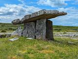 Poulnabrone DolmenHeritage attraction · 2.6 mi
Explorer Tom Poulnabrone Dolmen. Yeah, the big one in the Burre. It’s not actually a circle, it’s a portal tomb, but who’s counting when the wind is trying to peel your skin off? Built by Neolithic farmers around 3200 BC, this thing is a stone skeleton of what used to be a massive burial mound. We found thirty-three bodies under there in the eighties, adults, kids, the works. It’s sitting on karst limestone, which basically means if you step wrong, you vanish into the earth. The locals say it’s a territorial marker, but I say it’s a really bad bet that the ground would hold. Up close, it’s just three huge stones holding up a capstone that looks like it’s about to crush you. It’s desolate, it’s windy, and it’s absolutely brilliant. Don’t touch the stones, they’re older than your excuses.
 Gleninshing portal tombHeritage attraction · 3.8 mi
Explorer Tom Gleninshing portal tomb is a sacred site where ancient traditions and heritage are honored in County Clare.
 Inchiquin IslandIslet · 4.4 mi
Explorer Tom Inchiquin Island! A small islet with a name that sounds like it could be part of a royal lineage, what secrets does it keep in County Clare?
More cliffs, bays and coast in County Clare · All of County Clare

What do you know about this place?Tap to add a comment or ask a question