
What is recorded here
Faraid Head is a triangulation pillar in Highland, Scotland.
Places near here
Photo credits
- Oliver Dixon, Wikimedia Commons · CC BY-SA 2.0
- Alan Reid, Wikimedia Commons · CC BY-SA 2.0
- David Purchase, Wikimedia Commons · CC BY-SA 2.0
- Peter Moore, Wikimedia Commons · CC BY-SA 2.0
- Jim Barton, Wikimedia Commons · CC BY-SA 2.0
- Hilmar Ilgenfritz, Wikimedia Commons · CC BY-SA 2.0
- Mick Garratt, Wikimedia Commons · CC BY-SA 2.0
- Calum McRoberts, Wikimedia Commons · CC BY-SA 2.0
- Gordon Hatton, Wikimedia Commons · CC BY-SA 2.0
- Florian Fuchs, Wikimedia Commons · CC BY 3.0
- Richard Webb, Wikimedia Commons · CC BY-SA 2.0
 Gustav Pederson: Faraid Head, AtlanticSchooner (19th Century) · 570 yd
 Gob nan LeacHeadland · 605 yd
 CuarnagaigBay · 717 yd
 Balnakeil BayCraft · 1159 yd
 Clach Mhòr na FaraidIslet · 1268 yd
 An FharaidBurnt Mound (prehistoric) (possible), Midden (possible) · 1447 yd
 A' ChlèitIslet · 1570 yd
 SeanachaistealPromontory Fort · 1.7 mi
 Balnakeil ChurchRuins · 1.8 mi
 Balnakeil HouseLairds House (18th Century) (1744) · 1.8 mi
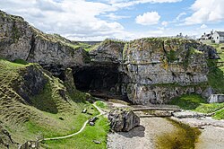 Smoo CaveCave(s), Midden, Pin(s) (bone) · 3.4 mi
 Geopark: Kyle of DurnessVisitor information · 3.7 mi
More archaeology and monuments in Highland · All of Highland

What do you know about this place?Tap to add a comment or ask a question