
What is recorded here
From the National Monuments Service (Archaeological Survey of Ireland) record OF029-010
Places near here
Photo credits
- Kieran Campbell, Geograph · CC BY-SA 2.0
- National Inventory of Architectural Heritage
- Morgan Treacy / Inpho, as credited by The Irish Times, www.irishtimes.com
- Maker not stated on source page, www.msn.com
- Maker not stated on source page, commons.wikimedia.org
- Corcs999, Wikimedia Commons · CC BY-SA 3.0
- Jonjobaker, Wikimedia Commons · CC BY-SA 4.0
- A.-K. D., Wikimedia Commons · CC BY-SA 4.0
- Maker not stated on source page, en.wikipedia.org
- Maker not stated on source page, production.english-heritage.org.uk
 mill (wind)295 yd
Explorer Tom The Mill at Cloghan Beg is holding a grudge against the weather for stealing its sails. It looks like a fancy hat that…
 Saint Cronan's Catholic ChurchChurch/chapel · 301 yd
Explorer Tom Saint Cronan's Catholic Church in Gortarevan is playing hard to get. The ghost inside is too lazy to haunt properly and…
 Lusmagh GAA pitchGAA ground · 331 yd
 CastleCastle, unclassified · 1258 yd
Explorer Tom Castle in Glenduff had a fiddler who played all night until the neighbours complained. Now there are no remains, just a…
 Mapped cemeteryCemetery · 1693 yd
Explorer Tom Mapped cemetery in County Offaly got lost by a Viking raiding party who were looking for gold. They wandered around for…
 Cloghan CastleCastle/fortified house · 1.2 mi
Explorer Tom Cloghan Castle survived an Elizabethan siege by playing dead and then rebuilding with better security, which is a move…
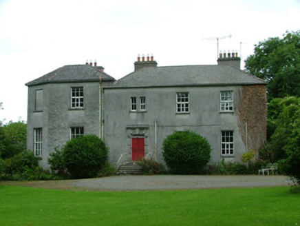 The RectoryRectory/glebe/vicarage/curate's house · 1.7 mi
Explorer Tom The Rectory in Lecarrow Glebe is feuding with the weather. A Gibbsian door and octagonal wing are just its alibis for…
 Fort ElizaBattery · 1.7 mi
Explorer Tom Fort Eliza in Kylebeg is a battery that has heard 'Is this where Napoleon landed?' too many times. It’s just stone and…
 canal (section of)1.8 mi
Explorer Tom Canal in Esker would write on its dating profile: 'Looking for deep conversation, not shallow water.' It was designed…
 CrossCross, High cross · 1.9 mi
Explorer Tom Cross in Kylebeg is called 'Kylebeg,' which sounds like a sneeze and a bedsheet having an argument. It’s part of a…
 Cromwells CastleBattery · 2.0 mi
Explorer Tom Cromwells Castle in Esker sounds like it was run by a very aggressive matchmaker who only liked soldiers with good…
 Cromwell's CastleHeritage attraction · 2.0 mi
Explorer Tom Cromwell's Castle is in a bit of a rivalry with a more famous castle nearby because it thinks its name sounds tougher…
More archaeology and monuments in County Offaly · All of County Offaly

What do you know about this place?Tap to add a comment or ask a question