
What is recorded here
From the National Monuments Service (Archaeological Survey of Ireland) record TN025-069
Places near here
Photo credits
- Maker not stated on source page, en.wikipedia.org
- Maker not stated on source page, commons.wikimedia.org
- National Inventory of Architectural Heritage
- Maker not stated on source page, jp.pinterest.com
- P L Chadwick, Geograph · CC BY-SA 2.0
- Maker not stated on source page, www.dreamstime.com
- Kmcnamee, Wikimedia Commons · CC BY-SA 4.0
- Discover Lough Derg, Wikimedia Commons · CC BY-SA 2.0
- Maker not stated on source page, tr.pinterest.com
 Fairy fort / earthen ringfort in CappadineFairy fort / earthen ringfort · 207 yd
Explorer Tom Fairy fort / earthen ringfort in Cappadine has decided its New Year's resolution is to finally stop pretending it…
 Church in Garraun (kilnarath Par.)Church · 1368 yd
Explorer Tom Church in Garraun was designed by a mother-in-law who couldn’t find the site, so she just drew a circle on the map.…
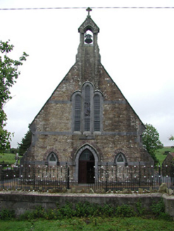 Saint Joseph's Catholic ChurchChurch/chapel · 1.2 mi
Explorer Tom Saint Joseph’s in Rossfinch is giving up fish for Lent but keeping its limestone dressings and sandstone walls, which…
 Church, GraveyardGraveyard · 1.3 mi
Explorer Tom Church, Graveyard in Kilmastulla was nearly sold off to buy a horse back in 1302, but it survived because people kept…
 Kilmastulla CemeteryCemetery · 1.3 mi
Explorer Tom The wind keeps picking on Kilmastulla Cemetery because it thinks the grass is too soft and wants to make it stiffen up…
 Earthwork in ClonaloughEarthwork · 1.5 mi
Explorer Tom Earthwork in Clonalough means 'The Hill That Refused To Be A Ring'. It tried to be round but got lazy and stayed oval.…
 Earthwork in FarneighEarthwork · 2.0 mi
Explorer Tom Earthwork in Farneigh is basically a giant cropmark secret that only satellites can see. It's like a ghost wearing a…
 Brian Boru Heritage CentreVisitor information · 3.4 mi
Explorer Tom Brian Boru Heritage Centre in County Clare is hiding a treasure chest inside the library that definitely contains…
 CastleCastle, unclassified · 3.4 mi
Explorer Tom Castle at Shantraud is proud of standing in the river near the flood-gates, which is either brave or very bad plumbing.…
 Smith O'Briens GAA pitchGAA ground · 3.5 mi
 Brian Boru FortHeritage attraction · 4.2 mi
Explorer Tom Brian Boru's Fort is a grand name, and I would be the first to announce the king built every bank by hand. Archaeology…
 St. John's Church of Ireland GraveyardGraveyard · 5.2 mi
Explorer Tom St. John's Church of Ireland Graveyard is proud of its perfectly symmetrical row of yew trees. It thinks they’re the…
More archaeology and monuments in County Tipperary · All of County Tipperary

What do you know about this place?Tap to add a comment or ask a question