
Places near here
Photo credits
- National Inventory of Architectural Heritage
- Mike Searle, Geograph · CC BY-SA 2.0
- Willow, Wikimedia Commons · CC BY 2.5
- Dalenevada, Wikimedia Commons · CC BY-SA 4.0
- kevin higgins, Wikimedia Commons · CC BY-SA 2.0
- Kieran Campbell, Wikimedia Commons · CC BY-SA 2.0
- JP, Geograph · CC BY-SA 2.0
 post box441 yd
Explorer Tom The Post Box in Lehinch witnessed a love story that went horribly wrong right next to it in the old days. It was made by London founders back when King George V was on the throne. Stop the car and lean out for a quick, cheeky wave.
 The MonasteryMonastery · 479 yd
Explorer Tom Lehinch Monastery is the most domestic religious institution in Ireland, which means it probably has a kettle on. Brother Lewis buried out front is definitely judging your outfit. Perfect detour for a quiet chat with stone walls.
Chapel HillForest · 1.3 miKilmalady HillMountain / peak · 2.2 miClara Bog BoardwalkWalking route · 2.3 mi Durrow MoatCastle, motte · 2.6 mi
Explorer Tom Durrow Moat is deeply suspicious of the postman and hides its head under the earth. Hugh de Lacy died there, so don't get too comfortable. Tell it a joke, it's been a long time since anyone did.
 European ash2.6 mi
Explorer Tom Another European ash in County Offaly has rabbits who think it’s their personal umbrella and shelter. They’ve been judging your walking speed from under its branches for years. Have a wander and a wonder about how much bark they’ve actually chewed.
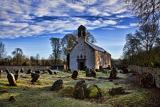 CrossCross, High cross · 2.7 mi
Explorer Tom Cross in Durrow Demesne is just a shaft fragment cemented into the wall like it’s giving up. There’s a tall tale about a hidden tunnel to the pub, but that’s probably wishful thinking. Stick around for the light changing, it's a show.
 Durrow High CrossVisitor attraction · 2.7 mi
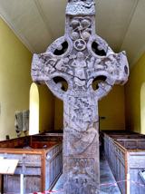 St. Columbkilles CrossCross, High cross · 2.7 mi
Explorer Tom St. Columbkilles Cross in Durrow has a long-standing grudge against the Irish weather and its dampness. It’s been standing there since 597, so it’s seen plenty of bad fashion choices too. Have a sandwich here and call it a heritage lunch.
 Ballycowan Castle (in ruins)House, fortified house · 4.7 mi
 Grand Canal WayWalking route · 6.0 mi
More mountains and hills in County Offaly · All of County Offaly

What do you know about this place?Tap to add a comment or ask a question