
What is recorded here
Easter Middleton is a farmhouse in Midlothian, Scotland.
Places near here
Picture notes
- Computer-made picture. It does not show this monument.
- Computer-made picture. It does not show this playground.
- James Denham, Wikimedia Commons · CC BY-SA 2.0
- M J Richardson, Wikimedia Commons · CC BY-SA 2.0
- Godot13, Wikimedia Commons · CC BY-SA 4.0
- Richard Webb, Wikimedia Commons · CC BY-SA 2.0
 Middleton HallMan-made underground passage (prehistoric) · 265 ydComputer-made picture. It does not show this monument.
 Children's playground916 ydComputer-made picture. It does not show this playground.
 Windy LawSettlement · 930 ydComputer-made picture. It does not show this monument.
 North MiddletonVillage · 1025 yd
 Borthwick FarmFarmhouse, Farmstead · 1356 yd
 Currie WoodWood · 1752 yd
 War MemorialMemorial · 1.0 mi
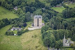 Borthwick Castle HotelCastle · 1.1 mi
 Halk LawMountain / peak · 1.3 mi
 Gorebridge, Harvieston CemeteryCemetery (20th Century) · 1.6 mi
 Castleton StripForest · 1.7 mi
 Ruther LawMountain / peak · 1.7 mi
More historic places in Midlothian · All of Midlothian

What do you know about this place?Tap to add a comment or ask a question