
What is recorded here
Dry stone obelisk is a monument or public art in North Yorkshire, England.
From the Geograph Britain and Ireland picture record 570819
The picture record does not grant access. Use signed public paths and do not enter private land without permission.
Places near here
Photo credits
- Gordon Hatton, Wikimedia Commons · CC BY-SA 2.0
- Philip Barker, Wikimedia Commons · CC BY-SA 2.0
- T Eyre, Wikimedia Commons · CC BY-SA 2.0
- Scott Robinson, Wikimedia Commons · CC BY-SA 2.0
- Chris Heaton, Wikimedia Commons · CC BY-SA 2.0
- Jonathan Thacker, Wikimedia Commons · CC BY-SA 2.0
- Antony McCallum, Wikimedia Commons · CC BY-SA 3.0
- DS Pugh, Wikimedia Commons · CC BY-SA 2.0
- Matthew Hatton, Wikimedia Commons · CC BY-SA 2.0
 Church of All SaintsListed building · 305 yd
 Old Byland HallListed building · 403 yd
 Low GillWood · 1115 yd
 Murton WoodWood · 1528 yd
 Wayside cross base on south side of the churchyard wall at ScawtonScheduled monument · 1.6 mi
 Path beside Waterfall GillWaterfall · 1.6 mi
 Ashberry HillMountain / peak · 1.6 mi
 Footpath descending to cross Waterfall GillWaterfall · 1.6 mi
 Peak ScarCliff · 1.8 mi
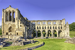 Rievaulx AbbeyListed building · 1.9 mi
 Rievaulx Abbey MuseumMuseum · 1.9 mi
 Bronze Age Burial MoundAncient burial place · 2.2 mi
More archaeology and monuments in North Yorkshire · All of North Yorkshire
What do you know about this place?