
Places near here
Photo credits
- Maker not stated on source page, www.pinterest.com
- National Inventory of Architectural Heritage
- C Michael Hogan, Wikimedia Commons · CC BY-SA 2.0
- Maker not stated on source page, www.flickr.com
- Maker not stated on source page, en.wikipedia.org
- Martin Dawes / Geograph Ireland, www.geograph.ie
- EecherplazGinkgo06.jpg : Cayambe derivative work: Ginkgotree ( talk ), Wikimedia Commons · CC BY-SA 3.0
- Ronnie Nijboer, Wikimedia Commons · CC0
- Maker not stated on source page, www.alamy.com
- Kenneth Allen, Wikimedia Commons · CC BY-SA 2.0
 Fairy fort / stone ringfort in Casheltown (gartan Ed)Fairy fort / stone ringfort · 210 yd
Explorer Tom Fairy fort / stone ringfort in Casheltown in County Donegal has very strong opinions on modern buildings, especially…
 Bridge CottageHouse · 575 yd
Explorer Tom Bridge Cottage in Casheltown (Gorkermore) is playing hide-and-seek with me. I bet two families feuded for decades just…
 Cashel Town Wedge TombsWedge tomb · 945 yd
Explorer Tom Cashel Town Wedge Tombs are unique because three galleries sit side-by-side in a single circular kerb. One roofstone is…
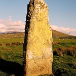 Standing stone in Calhaem (tc Dún Cionnaola)Standing stone · 1319 yd
Explorer Tom Standing stone in Calhaem is actually called a 'Giant’s Finger Stone' on old maps! I can’t help picturing a giant…
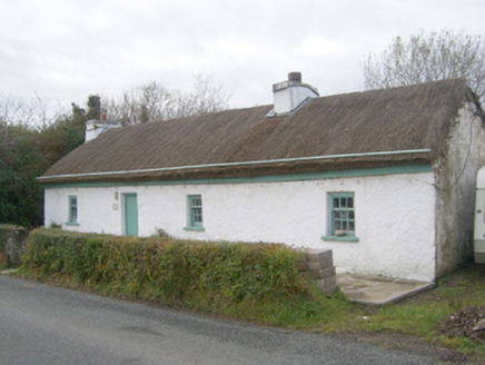 Springwell CottageHouse · 1443 yd
Explorer Tom Springwell Cottage has a rounded roof because it lives right next to the sea in those exposed spots. Built around 1860…
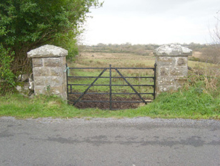 gates/railings/walls1.1 mi
Explorer Tom Gates in Cashelfean look like they belong on a grand estate, not a simple field. Built around 1890, those rock-faced…
 Aighan Cairn in the Relig EnclosureCairn, unclassified · 1.3 mi
Explorer Tom Aighan Cairn in the Relig Enclosure hides a proper mystery in its notched slabs. Patterson swears a dumbbell-shaped…
 Páirc Naomh Ultan, Naomh Ultan GAA, DunkineelyGAA ground · 1.4 mi
 Ginkgo1.5 mi
Explorer Tom Ginkgo in County Donegal had a fiddler play there all night long until he fell asleep leaning against its trunk, which…
 Wych Elm1.6 mi
Explorer Tom Wych Elm in County Donegal would explain the 1800s to a teenager as 'a time when we all had terrible fashion sense and…
 Graveyard in KilmacreddanGraveyard · 1.7 mi
Explorer Tom Graveyard in Kilmacreddan appears on an older six-inch map beside a church, but the 1983 survey found no trace of…
 Killaghtee Old Church GraveyardGraveyard · 2.0 mi
Explorer Tom Killaghtee Old Church Graveyard sits beside the old church; inside the graveyard, southwest of that church, the survey…
More mountains and hills in County Donegal · All of County Donegal

What do you know about this place?Tap to add a comment or ask a question