
What is recorded here
From OpenStreetMap (© OpenStreetMap contributors) n3786152942
Places near here
Photo credits
- National Inventory of Architectural Heritage
- Dr Neil Clifton, Geograph · CC BY-SA 2.0
- Kenneth Allen, Wikimedia Commons · CC BY-SA 2.0
- Andreas F. Borchert, Wikimedia Commons · CC BY-SA 4.0
- Kenneth Allen, Geograph · CC BY-SA 2.0
- Ian S, Geograph · CC BY-SA 2.0
 bridge1.7 mi
Explorer Tom Bridge in Drumanaught is a single-arched c. 1820 span that sends its little stream straight to the River Swilly. I picture the water splashing out of the arch, giggling as it races north to tell everyone about its new stone hat.
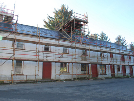 house, shop/retail outlet, store/warehouse1.8 mi
Explorer Tom House, shop in Milltown is an attractive terrace from the early 1800s that’s currently out of use but keeping its character. It retains natural slate roofs and battened doors, looking rather dignified despite the silence. Give it a good look for me!
 Newmills Corn and Flax MillsHeritage attraction · 1.8 mi
Explorer Tom Newmills Corn and Flax Mills has a waterwheel big enough to make me stop and watch the machinery do the hard work. Corn and flax kept different trades moving here. Heritage Ireland's 2026 visitor season has ended, so I would check the next opening date before making the trip.
 Battle of ScarrifholisBattle · 2.2 mi
Explorer Tom Scarrifholis was nearly sold for a horse in 1650 because nobody could agree on the price. It’s still annoyed about that deal, honestly. Stand there long enough and someone will definitely ask if you’re lost or just having an existential crisis.
 Battlefield in Ardahee,ballyconnelly (ballymacool Ed),bomany,doon GlebeBattlefield · 2.5 mi
Explorer Tom Battlefield in Ardahee in County Donegal is where history got messy and people stopped talking about it. It’s a field full of old arguments and new grass. Find a local and ask them the real story, then come back and tell me.
 Conwal Wheeled Cross SlabCross-slab · 3.1 mi
Explorer Tom Conwal Wheeled Cross Slab is a tiny, battered fragment that survived the mess of a 1968 tidy-up. It’s just the top half of a wheeled cross, weathered smooth on the cairn. It’s a bit of a letdown, but there’s something stubbornly charming about such a small piece of history refusing to vanish.
 Godfrey O'Donnell GraveslabGraveslab · 3.1 mi
Explorer Tom Godfrey O'Donnell Graveslab claims to be the final resting spot of a guy who died in 1258. It’s got a wheeled-cross with some fancy interlace that looks like Celtic knotting meets a bicycle wheel. The corner is broken, but the carving is still sharp enough to make you wonder if Godfrey was actually into cycling.
 Gregory HillMountain / peak · 3.5 mi
Explorer Tom Gregory Hill stands in County Donegal, keeping its access details firmly unknown. The name sounds like a word you’d mumble into your breakfast cereal, yet it sits there as a solid geological fact without offering a single helpful footpath.
 Three TopsMountain / peak · 3.8 mi
Explorer Tom Three Tops holds a long grudge against the weather for always picking on it first. The clouds hate it personally, I reckon. Take a breath of that air, it’s older than your car and smells like pure attitude.
 Tir na NogPub · 4.2 mi
Explorer Tom Tir na Nog sounds like a name invented by someone who had one too many pints. Bet they’ve got a special named after a ghost there. Tell it a joke, it's been a long time since anyone did.
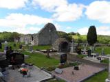 Stackarnagh Abbey GraveyardGraveyard · 4.2 mi
Explorer Tom Stackarnagh Abbey Graveyard has a gatepost detail I keep coming back to: a reused window fragment carved with a fish biting the end of a moulding, with a rough unicorn above it. The survey says the stone probably came from the church's ruined south window. I can enjoy the odd pair without inventing what the medieval carver meant.
 Oldtown BarPub · 4.4 mi
Explorer Tom Oldtown Bar in County Donegal is likely where all the locals go to complain about the weather until their voices give out. There is probably a hero nobody remembers who saved it from total collapse years ago. Bring your own legend, I've run out of good ones.
More mountains and hills in County Donegal · All of County Donegal

What do you know about this place?Tap to add a comment or ask a question