What is recorded here
From OpenStreetMap (© OpenStreetMap contributors) n3810048792
Places near here
Photo credits
- Andreas F. Borchert, Wikimedia Commons · CC BY-SA 4.0
- National Inventory of Architectural Heritage
- louise price, Geograph · CC BY-SA 2.0
- louise price, Wikimedia Commons · CC BY-SA 2.0
- N Chadwick, Geograph · CC BY-SA 2.0
- Ronnie Nijboer, Wikimedia Commons · CC0
- Eric Jones, Geograph · CC BY-SA 2.0
- David Dixon, Geograph · CC BY-SA 2.0
 St. Mary's Catholic ChurchChurch/chapel · 964 yd
Explorer Tom St. Mary's Catholic Church in Drumard, with its T-shape plan and three-stage tower added in 1892, is a striking landmark.
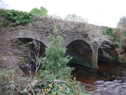 Eanymore BridgeBridge · 1.0 mi
Explorer Tom Eanymore Bridge has these sharp V-shaped stone tips pointing straight at the water, built around 1780. I bet they are there to stop the river trying to swim under the arches! It feels like a very aggressive hug for the water.
 Drumlaghtafin HillMountain / peak · 2.1 mi
Explorer Tom Drumlaghtafin Hill sits quietly between Leagans Hill and the Gortnalagan townland, keeping its access details firmly under wraps. The name is such a mouthful that I suspect it’s just trying to trip up anyone brave enough to attempt a pronunciation challenge without a map.
 Carraduffy / Killin Court TombCourt tomb · 2.2 mi
Explorer Tom Carraduffy / Killin Court Tomb is mostly a grassy hump with one solitary upright stone standing guard. The rest was demolished long ago, but old maps called it a Giant's Grave or even a friars' house. It’s a bit of a letdown now, but that lone slab makes you wonder what the full structure used to look like.
 Salthill CabinCafé · 2.8 mi
Explorer Tom Salthill Cabin is likely just a shed with a coffee machine and delusions of grandeur. It’s in County Donegal, so expect rain to pour straight through the roof. Take a photo if you find any actual salt anywhere.
 Tullytrasna Standing StonePublicly named standing stone · 2.9 mi
Explorer Tom Tullytrasna Standing Stone is probably just one very tall rock that forgot to sit down. It looks like it’s straining its ears, trying to hear if anyone is calling for help from the other side of the hill.
 Killin HillMountain / peak · 2.9 mi
Explorer Tom Killin Hill sits in County Donegal, recorded as a peak with access details that remain completely unknown. The caption mentions it is three kilometres from Frosses, which makes me wonder if the hill is just hiding behind its neighbour to avoid being found.
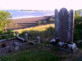 Killymard Old Church GraveyardGraveyard · 2.9 mi
Explorer Tom Killymard Old Church Graveyard encloses a church whose story changes after a bleak 1622 report: it was ruinous then, was later repaired or rebuilt, and remained in use until a new church opened at Ballydevitt in 1829. The earliest modern grave slab noted in the account dates to 1809. Two timelines fit inside one walled place.
 Wych Elm4.1 mi
Explorer Tom Another Wych Elm in County Donegal, probably just as sturdy and silent, keeping secrets in its twisted branches.
 Donegal Town HostelHostel · 4.2 mi
Explorer Tom Donegal Town Hostel is right in the middle of the madness. If you get lost, just follow the smell of cheap coffee to find your way back.
 Ballyboyle IslandIslet · 4.2 mi
Explorer Tom Ballyboyle Island takes its name from the O’Boyle clan, sub-chieftains of the O’Donnells who once ruled from Donegal Castle.
 Siege of DonegalSiege · 4.7 mi
Explorer Tom During the 1601 Siege of Donegal, an accidental gunpowder blast destroyed the town's abbey amid weeks of fighting. The abbey was no castle wall, but war managed to reach it all the same.
More mountains and hills in County Donegal · All of County Donegal

What do you know about this place?Tap to add a comment or ask a question