
What is recorded here
Current recorded use: Bridge.
From the Northern Ireland Historic Buildings Record record HB18/11/038
The official record and map point do not grant access. Many historic buildings are privately owned; view them only from public ground unless the owner allows entry.
Places near here
 Dundrum Inner BayPicnic place · 686 yd
 Manor HouseHouse · 804 yd
 Murlough National Nature ReserveNature reserve · 1225 yd
 Clock HouseHouse · 1235 yd
 Slidderyford DolmenArchaeological place · 1495 yd
_Dolmen_-_geograph.org.uk_-_4712447.jpg/250px-The_Slidderyford_(Wateresk)_Dolmen_-_geograph.org.uk_-_4712447.jpg "Photo: Eric Jones, Wikimedia Commons · CC BY-SA 2.0") Portal tomb: slidderyford dolmen in WatereskPortal Tomb: Slidderyford Dolmen · 1497 yd
Portal tomb: slidderyford dolmen in WatereskPortal Tomb: Slidderyford Dolmen · 1497 yd Mourne Coastal Route: Dundrum Main StreetVisitor information · 1547 yd
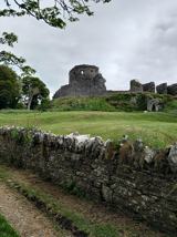 Dundrum CastleHeritage attraction · 1624 yd
 Dundrum castle in DundrumDundrum Castle · 1655 yd
 Castle PathWalking route · 1660 yd
 Murlough South End Nature Trail, MurloughWalking route · 1714 yd
 Murlough Nature ReserveNature reserve · 1.1 mi
Pictures: Eric Jones, Geograph · CC BY-SA 2.0; Eric Jones, Wikimedia Commons · CC BY-SA 2.0; GARRY HARPER, Geograph · CC BY-SA 2.0; N Chadwick, Geograph · CC BY-SA 2.0; Eschadew, Wikimedia Commons · CC BY-SA 4.0; jai, Geograph · CC BY-SA 2.0
More historic places in County Down · All of County Down
What do you know about this place?