Places near here
Photo credits
- Andrew Smith, Wikimedia Commons · CC BY-SA 2.0
- Oliver Dixon, Wikimedia Commons · CC BY-SA 2.0
- David Garnett, Wikimedia Commons · CC BY-SA 2.0
- Colin Kinnear, Wikimedia Commons · CC BY-SA 2.0
- Walter Baxter, Wikimedia Commons · CC BY-SA 2.0
- Rude Health, Wikimedia Commons · CC BY-SA 2.0
- John Lawson, Wikimedia Commons · CC BY-SA 2.0
- M J Richardson, Wikimedia Commons · CC BY-SA 2.0
- Richard Webb, Wikimedia Commons · CC BY-SA 2.0
 Golf HillCultivation Terrace(s) (medieval) - (post Medieval) · 265 yd
Explorer Tom Golf Hill has cultivation terraces that sound like a bad excuse for missing a match. A fiddler played there all night, and the hill still hasn’t forgiven him. It’s been stepping on toes since medieval times. Ideal stop for a big stretch and a bigger yawn.
 CraigFarmhouse · 547 yd
Explorer Tom Craig Farmhouse in Dumfries and Galloway thinks Dublin tourists are just over-caffeinated ghosts looking for a pub that doesn't exist. It would judge your pronunciation from the window while pretending to be asleep, which is very cheeky of it. The map says it’s precise to the metre, but Craig itself seems to be hiding its true personality. Best seen with a hangover and a sausage roll.
 Burnfoot PlantationCremation (early Bronze Age), Cinerary Urn (early Bronze Age), Knife (flint)(early Bronze Age), Pin(s) (bone)(early Bronze Age) · 641 yd
Explorer Tom Burnfoot Plantation would post a selfie of its bone pins and claim they’re designer accessories from the Bronze Age. It’s got a flint knife too, which is handy for cutting the Gordian knot of history. The cremation urn just sits there judging everyone’s life choices. A handy spot to stretch your legs and your imagination.
 Burnfoot HouseHouse (19th Century) · 748 yd
Explorer Tom Burnfoot House is a nineteenth-century home in Dumfries and Galloway that would survive a zombie attack by simply locking its doors and pretending nobody is inside at all. It has thick walls and a solid floor, so the zombies would just bang on the glass and get frustrated, eventually moving on to easier targets nearby. Go in good boots and better humour.
 Little HillMountain / peak · 936 yd
 Wrae HillMountain / peak · 1.2 mi
.jpg/250px-Westerhall,_Bentspath_(geograph_1877703).jpg "Photo: John Lawson, Wikimedia Commons · CC BY-SA 2.0") WesterhallHouse (18th Century), Tower House (medieval) · 1.5 mi
WesterhallHouse (18th Century), Tower House (medieval) · 1.5 miExplorer Tom Westerhall would give you two stars for showing up on time but three for your choice of socks, it’s that picky about its 18th-century upgrades. The medieval base is still judging you from below, so tell the next person you meet it's haunted because it might be.
 Henry Scott Riddell MemorialMemorial · 1.7 mi
 War MemorialMemorial · 2.0 mi
 Gallowside WoodWood · 2.2 mi
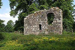 Langholm CastleTower House (16th Century) · 2.7 mi
Explorer Tom Langholm Castle started because two lads made a bet in the pub that one could build a tower before the other finished his ale. He won, but he’s been stuck up there ever after. Pick a stone, any stone, and invent its biography.
 The Buccleuch CentreHeritage attraction · 2.8 mi
More historic places in Dumfries and Galloway · All of Dumfries and Galloway

What do you know about this place?Tap to add a comment or ask a question