What is recorded here
Crumstane, Railway Bridge is a railway bridge in Scottish Borders, Scotland.
Places near here
Photo credits
- Maigheach-gheal, Wikimedia Commons · CC BY-SA 2.0
- Richard Webb, Wikimedia Commons · CC BY-SA 2.0
- Maker not stated on source page, en.wikipedia.org
- James Allan, Wikimedia Commons · CC BY-SA 2.0
- JThomas, Wikimedia Commons · CC BY-SA 2.0
- Walter Baxter, Wikimedia Commons · CC BY-SA 2.0
- Kevin Waterhouse, Wikimedia Commons · CC BY-SA 2.0
- Peter Wood, Wikimedia Commons · CC BY-SA 2.0
- Lisa Jarvis, Wikimedia Commons · CC BY-SA 2.0
- Maker not stated on source page, www.pinterest.com
- Jim Barton, Wikimedia Commons · CC BY-SA 2.0
- Douglas Banks, Wikimedia Commons · CC BY-SA 2.0
 Wedderburn Castle, the Lion GateGate (18th Century), Gate Lodge (18th Century) · 546 yd
 TurtletonChimney (19th Century), Coach House (19th Century), Farmhouse (19th Century), Farmstead (19th Century) · 678 yd
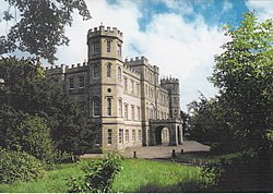 Wedderburn Castle, Stable BlockStable (18th Century) · 719 yd
 Wedderburn CastleCountry House (mid 18th Century) (1770)-(1775), Inscribed Stone · 744 yd
 ManderstonPheasantry (19th Century) · 773 yd
 Wedderburn Park, Burial GroundBurial Ground (late 15th Century), Cross (late 15th Century) · 872 yd
 Manderston HouseCountry House (18th Century), Country House (20th Century), Policies (18th Century) · 938 yd
 BrieryhillFarmhouse (mid 19th Century) · 1032 yd
 Manderston House, StablesStable (late 19th Century) (1895)-(1895), War Memorial (20th Century) · 1220 yd
 Wedderburn Castle, South LodgeGate (19th Century), Gate Lodge (19th Century) · 1404 yd
 Manderston House, Buxley, Estate OfficeEstate Office (19th Century) · 1430 yd
 Mungo's WallsTower (medieval) · 1453 yd
More historic places in Scottish Borders · All of Scottish Borders

What do you know about this place?Tap to add a comment or ask a question