What is recorded here
Situated on relatively high ground immediately N of a modern field wall c. 120m W of Templecronan church (CL010-021002-). The shaft of a limestone cross lies in two pieces, one on either side of a cross base. The E stone (L 1.47m; Wth 0.35-0.39m; T 0.2m) is slightly larger in all its dimensions (W stone: L 1.09m; Wth…
Read the whole record
From the National Monuments Service (Archaeological Survey of Ireland) record CL010-021004
Places near here
Photo credits
- Drow69, Wikimedia Commons · CC BY-SA 3.0
- P L Chadwick, Geograph · Creative Commons Attribution-ShareAlike 2.0
- Mac McCarron, Geograph · CC BY-SA 2.0
- Gordon Hatton, Geograph · Creative Commons Attribution-ShareAlike 2.0
- Mac McCarron, Geograph · Creative Commons Attribution-ShareAlike 2.0
- Mike Searle, Wikimedia Commons · Creative Commons Attribution-ShareAlike 2.0
- C Michael Hogan, Geograph · CC BY-SA 2.0
- PaulT, Wikimedia Commons · CC BY-SA 4.0
- Joseph Mischyshyn, Geograph · CC BY-SA 2.0
- AndyCorbley, Wikimedia Commons · CC BY-SA 4.0
- Roger Diel, Geograph · CC BY-SA 2.0
- MarvinVells, Wikimedia Commons · CC BY-SA 3.0
 Templecronan (in ruins)Church · 142 yd
Explorer Tom Templecronan is a small 12th-century oratory dedicated to St Cronan, featuring a Romanesque carved animal head on its jamb.
 Saint Columba's Catholic ChurchChurch/chapel · 1431 yd
Explorer Tom Saint Columba's Catholic Church in Crughwill replaced an earlier ruin, and its 1861 structure still holds that deep, historic architectural charm today.
 Castle in ruinsCastle, tower house · 1.3 mi
Explorer Tom Welcome to the crumbling Castle in ruins, where the O’Loughlins once held firm on this limestone outcrop near Carran Turlough.
 Holy Well1.9 mi
Explorer Tom This Holy Well in Glencolumbkille South features a carved cross cemented into limestone, said to heal eyes and feet.
 Grave YardGraveyard · 2.0 mi
Explorer Tom Graveyard in Glencolumbkille South hides a small carved stone head found in its mortared wall, guarding graves that date mostly to the nineteenth century.
_-_geograph.org.uk_-_4570444.jpg/250px-Castles_of_Munster,_Cappagh,_Clare_(1)_-_geograph.org.uk_-_4570444.jpg "Photo: Mike Searle, Wikimedia Commons · Creative Commons Attribution-ShareAlike 2.0") Cappagh CastleCastle · 2.2 mi
Cappagh CastleCastle · 2.2 miExplorer Tom Cappagh Castle rises as a tall stone ruin in open rocky grassland, standing firm under the cloudy sky of County Clare.
 The Portal TombVisitor information · 3.2 mi
Explorer Tom The Portal Tomb has me checking the name twice; the account will not tell me if a rat ever set paw here
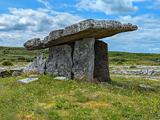 Poulnabrone DolmenHeritage attraction · 3.2 mi
Explorer Tom Poulnabrone Dolmen is an enigmatic stone circle in County Clare, a relic of prehistoric craftsmanship and enduring mystery.
 Poulnabrone - Burren GeositeVisitor information · 3.2 mi
Explorer Tom Poulnabrone - Burren Geosite has me thinking it's a place where the earth has a special shape; the account doesn't say what's special about it.
 Gleninshing portal tombHeritage attraction · 3.8 mi
Explorer Tom Gleninshing portal tomb is a sacred site where ancient traditions and heritage are honored in County Clare.
 Cave of the Wild HorsesCave · 4.0 mi
Explorer Tom Cave of the Wild Horses sits six kilometers west of Carran, evoking images of untamed creatures in the dark.
 Aillwee CaveCave · 4.5 mi
Explorer Tom Aillwee Cave is famous for its waterfall, making it a spectacular and very wet welcome to County Clare caving.
More archaeology and monuments in County Clare · All of County Clare

What do you know about this place?Tap to add a comment or ask a question