
Places near here
Photo credits
- Night of the Big Wind, Wikimedia Commons · CC BY-SA 3.0 nl
- Keith Salvesen, Wikimedia Commons · CC BY-SA 2.0
- P L Chadwick, Wikimedia Commons · CC BY-SA 2.0
- Muimhneach, Wikimedia Commons · CC BY-SA 4.0
- Andreas F. Borchert, Wikimedia Commons · CC BY-SA 4.0
- National Inventory of Architectural Heritage
- Bob Jones, Geograph · CC BY-SA 2.0
- Adrian King, Geograph · CC BY-SA 2.0
- Kmcnamee, Wikimedia Commons · CC BY-SA 4.0
- Colin Park, Geograph · CC BY-SA 2.0
 Cross in RoughanCross · 1046 yd
Explorer Tom Cross in Roughan, County Clare would win the lotto and buy a bigger hill to stand on. It’s currently just a fragment…
 Sheela na GigPublic artwork · 1553 yd
Explorer Tom Sheela na Gig in County Clare is showing off her behind to every single passerby with zero shame or apology. She says…
 Killinaboy Round TowerVisitor attraction · 1557 yd
Explorer Tom Killinaboy Round Tower and the nearest tree are in a fierce rivalry over who stands taller, even though the tree has…
 Sheela-na-gig in KillinaboySheela-na-gig · 1557 yd
Explorer Tom Sheela-na-gig in Killinaboy is built into the church wall, looking like a grim, ribbed statue pouring something out…
 Kilinaboy Church (in ruins)Church · 1561 yd
Explorer Tom Kilinaboy Church holds a fake world record for being the most photogenic ruin in County Clare, according to its own PR…
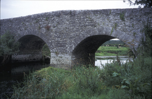 Poplar BridgeBridge · 1666 yd
Explorer Tom Poplar Bridge is a hump-back charmer from 1810 that looks like it's trying to hide a secret in its arches. I bet it was…
 Inchiquin Castle (in ruins)Castle, tower house · 1.3 mi
Explorer Tom Inchiquin Castle is perched on a rocky bluff, looking down its nose at the lough below. Built by a king, ruined by…
Inchiquin CastleRuins · 1.3 miExplorer Tom Inchiquin Castle is secretly proud of its potato, which it claims grew to the size of a small dog. It swears the spud…
 Inchiquin IslandIslet · 1.5 mi
Explorer Tom Inchiquin Island was built on a bargain where someone traded a secret recipe for a chunk of land in Lough Inchiquin.…
 Rock IslandIsland · 1.6 mi
Explorer Tom Rock Island is having a bit of a mood today, refusing to be the best man at its own wedding. It’s just standing there…
 Corofin GAA pitchGAA ground · 2.4 mi
 Burren Centre KilfenoraVisitor information · 4.8 mi
Explorer Tom The Burren Centre in Kilfenora is a sensible first stop before trying to make sense of north Clare's limestone hills. I…
More archaeology and monuments in County Clare · All of County Clare

What do you know about this place?Tap to add a comment or ask a question