
Places near here
Photo credits
- Jack Bracken, Wikimedia Commons · CC BY-SA 3.0
- Patrice78500, Wikimedia Commons · Public domain
- Colin Park, Wikimedia Commons · CC BY-SA 2.0
- National Inventory of Architectural Heritage
- Rod Grealish, Geograph · CC BY-SA 2.0
- John Martin, Geograph · CC BY-SA 2.0
- Kenneth Allen, Geograph · CC BY-SA 2.0
- Kenneth Allen, Wikimedia Commons · CC BY-SA 2.0
- Eric in SF, Wikimedia Commons · CC BY-SA 3.0
.jpeg/250px-Staghall_Mountain_(34093998).jpeg "Photo: Jack Bracken, Wikimedia Commons · CC BY-SA 3.0") Staghall MountainMountain / peak · 1.0 mi
Staghall MountainMountain / peak · 1.0 miExplorer Tom Staghall Mountain has a proper view captured for us, and it looks like a solid old friend standing up in County Donegal. I bet the air up there is crisp enough to make you sneeze before you even start climbing.
 Páirc Naisiúnta Ghleann Bheatha - Glenveagh National ParkNature reserve · 1.2 mi
Explorer Tom I spotted a golden eagle and immediately pretended it had come to inspect me. Glenveagh National Park spreads across roughly 170 square kilometres of Donegal, which makes any plan to see it all before lunch a fine piece of nonsense. Lough Veagh runs through the glen, mountains rise around it, and red deer move through the wider country. Golden eagles were reintroduced here in 2000, a bold return for a bird once lost from the region. This landscape also carries the history of the Derryveagh Evictions, when 224 people were driven from the estate in 1861; the views cannot be separated from that record. The deer have better routes through this country than any shortcut I could invent. Later owner Henry McIlhenny gave the estate to the Irish state in the 1970s. Public park paths offer different lengths of walk, while castle tours have separate arrangements, so check routes and weather before setting off. Choose one stretch of glen and let it be enough; the mountain will still be here for the next visit.
Maumlack Corrie HeadwallCliff · 1.3 miExplorer Tom Maumlack Corrie Headwall in County Donegal has strong opinions about that tiny road leading up to it, mostly that it should be wider for its ego. It stands there looking like it’s judging your hiking boots and your life choices all at once. Stick around for the light changing, it's a show.
 Drumnalifferny MountainMountain / peak · 1.7 mi
Explorer Tom Drumnalifferny Mountain is a peak in County Donegal with its access details currently unknown. A photo shows the view towards Slieve Snaght from the summit, which feels like the mountain is showing off its best friend while we are still stuck trying to find the front door.
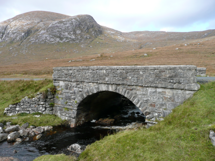 Droichead an Phoill Ghlais [Pollglass Bridge]Bridge · 2.0 mi
Explorer Tom Droichead an Phoill Ghlais [Pollglass Bridge] crosses the River Barra in one broad stone arch, built around 1860. Rock-faced granite blocks frame the arch, while the parapet walls have been rebuilt. A single span does the work here, with the hills of Crockbrack and Moylenanav behind it.
Dunlewy Early Church EnclosureEcclesiastical enclosure · 2.1 miExplorer Tom Dunlewy Early Church Enclosure hides a grooved cross-slab near the foot of Errigal. It’s a bit of a mess with scattered stones and broken walls, but that carved detail is a proper gem to find in the mud.
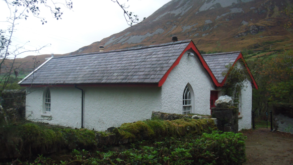 Dunlewy HouseGate lodge · 2.1 mi
Explorer Tom Dunlewy House is a gate lodge built around 1850, with double gables and pointed windows. It looks as though the gate was given a little castle to mind. That is a lot of architecture for a gate to keep track of.
 Astelleen Burn WaterfallWaterfall · 2.5 mi
Explorer Tom Astelleen Burn Waterfall is three kilometres from Glenveagh and seems to be guarded by a ghost who is far too lazy to actually haunt anyone properly. The Irish name translates to 'waterfall of the flood,' which is dramatic for something that mostly just slops along quietly. Go now, before it gets famous.
 Errigal Youth HostelHostel · 3.5 mi
Explorer Tom Errigal Youth Hostel in County Donegal is where dreams go to get squished under mattresses. It's cozy if you define cozy as 'crowded' and 'slightly damp'. Bring a notebook and write the bit I made up for your diary.
 McGeady's BarPub · 3.7 mi
Explorer Tom McGeady’s Bar is sitting there looking suspiciously quiet in County Donegal, waiting for someone to ask if they’ve had any ghosts. Order something strong and blame all the damp on them instead, because that’s just how it works sometimes. Go in good boots and better humour.
 Walled GardenGarden · 4.7 mi
Explorer Tom Here lies a Walled Garden in the wilds of County Donegal, where the wind probably howls just to see if you're paying attention. I imagine it's a cozy little secret for customers seeking shelter from that famous Irish rain.
 Wheel tree4.7 mi
Explorer Tom Wheel tree is the life of every wedding, standing there in the background looking incredibly dramatic while everyone else focuses on the cake. It knows exactly how to pose its branches for the best photos without even trying. It’s got that natural charisma that no amount of styling can replicate. Ideal spot for a dramatic phone call.
More mountains and hills in County Donegal · All of County Donegal

What do you know about this place?Tap to add a comment or ask a question