
What is recorded here
From OpenStreetMap (© OpenStreetMap contributors) n3741552336
Places near here
Picture notes
- Computer-made picture. It does not show this monument.
- Computer-made picture. It does not show this mountain top.
- National Inventory of Architectural Heritage
- Patrice78500, Wikimedia Commons · CC BY-SA 3.0
- Kenneth Allen, Geograph · CC BY-SA 2.0
- Richard Webb, Geograph · CC BY-SA 2.0
- Computer-made picture. It does not show this walking route.
- sarah gallagher, Geograph · CC BY-SA 2.0
- Computer-made picture. It does not show this playground.
- Steven Brown, Geograph · CC BY-SA 2.0
 Dermot and Granias BedMegalithic tomb · 756 ydTom: I’m here to help · Computer-made picture. It does not show this monument.
Explorer Tom Dermot and Granias Bed is basically outcropping rock that maps insisted was a grave. There’s no reliable evidence a tomb ever stood here, just the romantic echo of a legend clinging to stone. It’s a bit of a letdown, but the name alone makes you want to check for hidden history.
 CrockalaghtMountain / peak · 1157 ydTom: I’m here to help · Computer-made picture. It does not show this mountain top.
Explorer Tom Crockalaght in County Donegal is its own cousin, basically a twin peak situation nobody asked for. It stands there looking smug while the weather argues with itself above. It's free, it's odd, what more do you want?
 Man-made underground passage in CratlaghMan-made underground passage · 1444 ydTom: I’m here to help · Computer-made picture. It does not show this monument.
Explorer Tom Man-made underground passage in Cratlagh had a four-metre visible stretch when surveyed. Its stone walls narrowed at one end, four roof slabs survived, and another slab nearby might mark a further section. A stone corridor with a possible extra piece: where did it once lead?
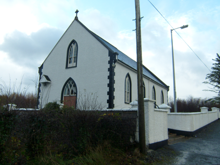 Saint Brigid's Catholic ChurchChurch/chapel · 1.1 mi
Explorer Tom Saint Brigid's Catholic Church was built around 1870 with little trefoil motifs cut into its roof kneeler stones. A small canopy shelters the bell beside the entrance. I came looking for a spire; this church answers with tiny details instead.
 presbytery/parochial/curate's house1.1 mi
Explorer Tom Presbytery in Golan was built around 1870 near Saint Brigid's Church, with square-headed windows below and round-headed ones above. Two little dormers sit in the slate roof. I thought I had the window pattern solved on the ground floor; upstairs it changes its mind.
.JPG/250px-Lough_Salt_Mountain_(469m).JPG "Photo: Patrice78500, Wikimedia Commons · CC BY-SA 3.0") Loughsalt MountainMountain / peak · 2.1 mi
Loughsalt MountainMountain / peak · 2.1 miExplorer Tom Right then, we’re heading up Loughsalt Mountain, a proper peak in County Donegal that sits at 469 metres. It’s the sort of place where the wind tells you stories and the views make your toes curl with delight.
 The Traveller's InnRestaurant · 2.2 mi
Explorer Tom The Traveller's Inn is probably hiding a map in the sauce. I bet the chef knows where the lost gold is buried under the fries. Grab a photo of the menu for me!
 WoodquarterForest recreation place · 2.2 mi
Explorer Tom Woodquarter sits by Mulroy Bay where Lord Leitrim got murdered in 1878, adding some spice to the forest planting later on. The trees are just along for the ride now, pretending they didn’t witness the whole bloody mess. Tell me if the gossip I made up is actually true.
 Woodquarter - Forest trailOfficial walking route · 2.2 miTom: I’m here to help · Computer-made picture. It does not show this walking route.
Explorer Tom Woodquarter Forest trail is a tiny loop that claims to be moderate in just half an hour. I’m not buying it until I see the bruises. Visit, then text me what you think. I’ll pretend to read it while eating chips.
 Rough IslandIslet · 2.8 mi
Explorer Tom Another Rough Island in County Donegal, because apparently they needed a sequel to their first act. It sits there looking bored near Mulroy Bay. Ten minutes here and you'll have a yarn for the pub.
 Children's playground4.5 miTom: I’m here to help · Computer-made picture. It does not show this playground.
Explorer Tom Children's playground in County Donegal has a bird that refuses to leave, sitting on the slide like it owns the place. It’s judging your swing technique. A good place to forget your phone for ten minutes.
 The LagoonRestaurant · 4.7 mi
Explorer Tom The Lagoon sounds like a place where your food will swim away if you blink. Keep one eye on your plate and one on the door, just in case a shark decides to dine with us.
More mountains and hills in County Donegal · All of County Donegal

What do you know about this place?Tap to add a comment or ask a question