
What is recorded here
Coull Parish Church Manse is a manse in Aberdeenshire, Scotland.
From the Historic Environment Scotland record 179960
The historic-place record does not grant public access. Check current conditions and ownership before entering land or a building.
Places near here
Photo credits
- Andrew Wood, Wikimedia Commons · CC BY-SA 2.0
- Stanley Howe, Wikimedia Commons · CC BY-SA 2.0
- Mick Garratt, Wikimedia Commons · CC BY-SA 2.0
- Richard Webb, Wikimedia Commons · CC BY-SA 2.0
- Anne Burgess, Wikimedia Commons · CC BY-SA 2.0
 Coull BridgeRoad Bridge · 180 yd
 CoullFarmstead, Mill (possible) · 321 yd
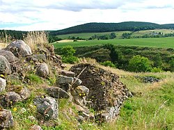 Coull CastleCastle (medieval), Coin(s) · 352 yd
 KirktonBuilding, Enclosure, Sundial · 374 yd
 SpringbankField System · 871 yd
 Oldtown PlantationForest · 1.2 mi
 Court HillMountain / peak · 1.6 mi
 Tomnaverie Stone CircleHeritage attraction · 1.7 mi
 Muirton WoodForest · 1.9 mi
 Scar HillMountain / peak · 2.0 mi
 Aboyne CastleCastle (17th Century), Country House (18th Century), Hospital (first World War), Motte (medieval) · 2.1 mi
 MacRobert Memorial HallMemorial · 2.2 mi
More archaeology and monuments in Aberdeenshire · All of Aberdeenshire
What do you know about this place?