
Places near here
Photo credits
- National Inventory of Architectural Heritage
- Kenneth Allen, Geograph · CC BY-SA 2.0
- louise price, Geograph · CC BY-SA 2.0
- Rossographer, Geograph · CC BY-SA 2.0
- Andreas F. Borchert, Wikimedia Commons · CC BY-SA 4.0
- louise price, Wikimedia Commons · CC BY-SA 2.0
- David Dixon, Wikimedia Commons · CC BY-SA 2.0
- Malene Thyssen, Wikimedia Commons · CC BY-SA 3.0
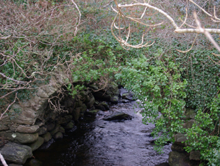 The Lough Head BridgeBridge · 1.4 mi
Explorer Tom The Lough Head Bridge was already an old crossing when later roads took over. Built around 1770, it had become overgrown and unused when heritage surveyors described it. The single stone arch looks to me like an old storyteller letting the newer bridges do the shouting.
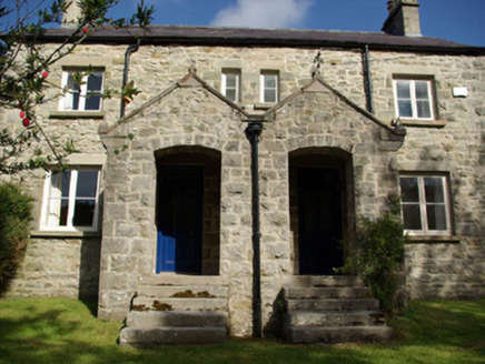 The CottagesHouse, worker's house · 1.5 mi
Explorer Tom The Cottages were built around 1895 with paired timber casement windows. I keep wondering if the workers used them to wave at each other across the gap, or maybe just to double-check their reflections. Those little porch steps look like they’re waiting for a very important delivery.
 HughiesPub · 1.7 mi
Explorer Tom Hughies in Killybegs is where locals feel like kings, even if nobody knows who Hugh actually was. It would survive a zombie attack by hiding behind the strong pints. It's the kind of place that makes a dull Tuesday interesting.
 Bay View HotelHotel · 1.7 mi
Explorer Tom Bay View Hotel faces north-northwest, perfect for watching the weather turn into a proper grumble. I bet a fiddler played there all night and never stopped. Go now, before it gets famous and starts charging double.
 CrownaradMountain / peak · 1.8 mi
Explorer Tom Crownarad stands at 493 metres, towering over its neighbour Fintragh which sits a mere 381 up. That height difference makes Crownarad look like it’s been wearing an invisible hat while Fintragh tries to keep up.
 FintraOfficial bathing water · 2.1 mi
Explorer Tom Fintra gives me a grand view before I reach the sand: the road drops toward Donegal Bay, with dunes and grassy hills behind the shore. There is a lagoon at the far end from the car park. I would let someone else call that steep, narrow road a quick nip down.
 St Catherine's Friary GraveslabGraveslab · 2.2 mi
Explorer Tom St Catherine's Friary Graveslab marks John Lindsey, who died young at twenty-seven back in 1685. The slab is broken and its coat of arms has vanished, leaving just the incised Roman script to tell his story. It’s a bit sad that the family crest got lost, but the words remain.
 St Catherine's WellHoly well · 2.3 mi
Explorer Tom St Catherine's Well in Killybegs was once a famous pilgrimage site, but there’s a daft legend that a Protestant rector tried to fill it up with dirt. The next day, a spring burst into his drawing room, terrifying his wife until he reopened the well. It’s still cleaned for St. Catherine’s Day, sitting beside the ruins of 'Cat Castle' in marshy pasture.
 Cat CastleCastle, tower house · 2.3 mi
Explorer Tom Cat Castle is named after St. Catherine, but really it’s just a tiny stone corner standing on a hill above Killybegs Harbour. It’s been shrinking since 1355, and now only a 3-metre wall survives. It’s a bit pathetic, sure, but looking out over the harbour makes you wonder what that bishop’s manor looked like when it was whole.
 Balbane HillMountain / peak · 2.4 mi
Explorer Tom Balbane Hill has a photo of itself that looks like it's posing for a magazine. I bet the oldest stone there is judging your hiking boots right now. Spot the oldest stone and give it a name.
 Rashenny PointHeadland · 2.8 mi
Explorer Tom Rashenny Point thinks its secret talent is competitive napping, and honestly? It’s good at it. The headland is just vibing out there in the sun. Take the long way round, because this spot deserves the extra effort and scenic drive.
 European Beech2.8 mi
Explorer Tom European Beech in County Donegal is just a tree, but a fancy one that thinks it runs the place. It’s probably been there longer than the local council has had a proper meeting. Perfect spot to practise your best tour-guide voice, say 'ahoy' and see if it flinches.
More mountains and hills in County Donegal · All of County Donegal

What do you know about this place?Tap to add a comment or ask a question