Places near here
Photo credits
- National Inventory of Architectural Heritage
- Jonathan Thacker, Geograph · CC BY-SA 2.0
- The Speckled Bird, Wikimedia Commons · CC BY-SA 4.0
- Algirdas at Lithuanian Wikipedia, Wikimedia Commons · Public domain
- Papp László Gyula, Wikimedia Commons
Explorer Tom St Patricks Well in Castlewidenham is where you go to cure your ego, not just your rash. The water is pure, but the vibes are suspiciously holy for a puddle in the pasture. Pop by and tell it it's looking well.
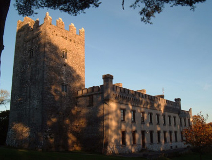 Blackwater CastleCountry house · 369 yd
Explorer Tom Blackwater Castle in Castlewidenham started as a medieval tower house around 1475 and was later extended into a country house hotel. The fanciful castellations contrast with the functional battlements, creating a profile that looks like it stepped out of a fantasy novel onto the river Awbeg banks.
 Bridge MillMill (water) · 590 yd
Explorer Tom Bridge Mill has a secret talent for making excellent flour and terrible small talk with its neighbours. Its timber sash windows are looking out for the community because they’re too lazy to move. It’s owned by locals now, so treat it like a shy friend who just moved in.
Fulacht fia in Kilcummer UpperFulacht fia · 710 ydExplorer Tom Fulacht fia in Kilcummer Upper is invisible unless you plough the field hard. Locals say burnt material pops up when the tractor goes by. So it’s there, but only for tractors and very lucky farmers.
Blackwater (Avondhu) WayWalking route · 2.5 miExplorer Tom Blackwater (Avondhu) Way in County Cork is doing that thing where it pretends to be easy but has a secret grudge about your footwear. Rumor says a dance party started here last Tuesday and someone’s still trying to find their partner, which explains the weird footprints you’re seeing right now. Bring the dog, it'll have opinions.
Priest's WoodForest · 3.0 miExplorer Tom Priest’s Wood has a favourite song, which is just the sound of wind through the branches on a Tuesday evening. It thinks it sounds very spiritual and profound, to be honest. Snap one photo, then put the phone away and actually look at what’s around you.
 Ballyhooly CastleCastle · 3.2 mi
Explorer Tom Ballyhooly Castle in County Cork is an early sixteenth-century tower house. You can see part of the bawn wall on the right if you look closely. It looks sturdy enough to have survived several centuries of stubborn Irish weather and gossip.
Knocknaskagh North TopMountain / peak · 3.6 miExplorer Tom Knocknaskagh North Top was designed by a mother-in-law who wanted to make sure you felt small and inadequate. It’s got that sharp edge that says 'you’re not good enough yet' while offering a nice view anyway. Go with someone who loves old stuff and watch them melt.
 Glanworth CastleCastle · 4.8 mi
Explorer Tom Glanworth Castle in County Cork is probably dreaming of being a grand mansion instead of just standing there looking slightly tired. It might have a hidden cellar full of old letters and gossip. Peek inside.
 Doneraile CourtFoot bridge · 5.5 mi
Explorer Tom Hunting Bridge at Doneraile Court is humpbacked, which means it’s got character and maybe a bad knee. It’s part of the demesne group, so it’s never alone. The local lad claims he invented the concept of bridges next to this one. Trust him, not me.
 Pedunculate Oak5.6 mi
Explorer Tom Pedunculate Oak in County Cork claims there’s a shortcut through the roots, but it’s definitely not a shortcut. It’s more of a spiritual journey. Tell it a joke, because it’s been a long time since anyone did.
 Doneraile Wildlife ParkPark · 5.9 mi
Explorer Tom Doneraile Wildlife Park is where Tom goes to look for deer and immediately starts acting as if he has been appointed their estate manager. North of Mallow, the paths slip through a 160-hectare landscape of old trees, water and lawns around Doneraile Court; the deer, quite properly, ignore his promotion. This is the St Leger family's former estate, with parkland laid out in the naturalistic style associated with Capability Brown. Limestone bridges cross the grounds, while cascades and fish ponds make useful excuses to stop pretending you are on a brisk walk. The walled garden and gardeners' cottages add another layer beyond the open grazing. You can choose among graded, colour-coded routes instead of trying to conquer the whole estate before lunch. Keep an eye out for red, fallow and sika deer and the estate's Kerry cattle. Heritage Ireland also mentions red squirrels and otters by the Awbeg River, though neither has agreed to appear on Tom's timetable. The trees include veterans several centuries old, and boxes provide shelter for bats. There is a children's playground too, which may be the one part of the estate where Tom can outrun anybody. The parklands are free to enter during published gate hours; the Court itself has separate guided tours and admission. Dogs must be kept on a lead, a sensible rule when the other residents have antlers. Check the current closing time before setting off, as winter gates close earlier and individual entrances shut in stages. Take a route, watch for wildlife, and let the deer keep charge of Doneraile.
More caves in County Cork · All of County Cork

What do you know about this place?Tap to add a comment or ask a question