Places near here
Photo credits
- Christine Johnstone, Geograph · CC BY-SA 2.0
- Eric Jones, Wikimedia Commons · CC BY-SA 2.0
- Albert Bridge, Wikimedia Commons · CC BY-SA 2.0
- Albert Bridge, Geograph · CC BY-SA 2.0
- User:SeamusSweeney, Wikimedia Commons · CC BY-SA 3.0
- N Chadwick, Geograph · CC BY-SA 2.0
- Elkay62, Wikimedia Commons · CC BY-SA 4.0
 Cistercian abbey (site of), now modern C of I church (c.f. hb 24/15/2) in Town Parks (comber)Cistercian abbey (site of), now modern C of I church (c.f. hb 24/15/2) · 363 yd
Explorer Tom This used to be a Cistercian abbey but now it’s just a modern church, so it’s like a grandpa who changed his haircut. A handy spot to stretch your legs and let your imagination run wild without any constraints.
 Second Comber Presbyterian ChurchChurch · 408 yd
Explorer Tom Second Comber Presbyterian Church in Town Parks has been hiding a scandal since the 1830s involving a very loud argument about whose turn it was to clean the altar. It’s still pretending everything is fine while secretly judging everyone who walks past its gate. Bring a map, get lost anyway, that's the fun.
 The Gillespie MonumentMemorial · 448 yd
Explorer Tom The Gillespie Monument in Town Parks had its first owner plan an escape route through the garden, but he forgot to dig the hole. He’s been stuck there ever since, watching people trip over his name. Bring the dog, it'll have opinions about who was right.
 Walled GardenGarden · 1.9 mi
Explorer Tom Walled Garden in County Down has strong opinions on modern buildings, specifically that they’re too tall and not enough brick. The walls feel like they’re whispering gossip about everyone who’s ever walked past without appreciating the structural integrity of the past. If it rains, blame me.
 Rough IslandIslet · 2.0 mi
Explorer Tom Rough Island’s family tree is mostly made up, with generations of ancestors who were definitely real but also definitely not. It sits there with a causeway that looks like it was drawn by a toddler with a crayon. Stand there long enough and someone will ask if you're lost.
 Castle Espie Wetland CentreNature reserve · 2.2 mi
Explorer Tom Castle Espie Wetland Centre in County Down is feuding with the next village over who stole its best heron. The ducks are taking sides, and the mud is getting very political. A handy spot to stretch your legs and your imagination.
 Brickworks; cf ihr 2781 in Castle EspieBrickworks · 2.3 mi
Explorer Tom Brickworks in Castle Espie used to be an industrial site full of Hoffmann kilns and smoke. Now it’s a nature reserve where the bricks are slowly being reclaimed by mud. Ring your granny; she’ll tell you the real story about the soot.
 Scrabo HillMountain / peak · 2.4 mi
Explorer Tom Scrabo Hill in County Down is currently being judged by the local sheep, who think its tower looks ridiculous for something that can’t even fly. They’ve decided to stand very close to the base and stare up at it with intense disapproval, which is a lot of work for animals. Bring the dog, it'll have opinions.
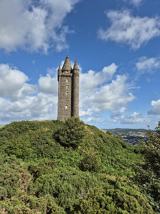 Scrabo TowerHeritage attraction · 2.4 mi
Explorer Tom I saw Scrabo from miles away and pretended I meant to find it. Scrabo Tower rises above Newtownards like a 41 metre stone exclamation mark, visible long before you reach the hill. It was built to commemorate Charles Vane, the third Marquess of Londonderry, which explains its original name, the Londonderry Monument, despite the city being far away. The tower also sits on the site of a prehistoric hill fort, so it was hardly the first occupant to notice the commanding position. Vane himself had changed his surname from Stewart after marrying a rich heiress, a small detail for anyone who thinks grand families never rebrand. If I built a tower for every important person, somebody would ask where I found the stone. The surrounding hill is a public walking destination with wide views; access inside the tower can vary, so check current opening before counting on the stairs. Even from outside, the stonework and sweep over Strangford Lough are worth the climb. Scrabo knew how to be seen before the tower arrived.
 Kiltonga Nature ReserveNature reserve · 3.4 mi
Explorer Tom Kiltonga Nature Reserve would describe the 1800s to a teenager by saying it was all very dramatic, with everyone wearing itchy wool and having strong opinions about nothing in particular. It thinks back then people were just too busy being alive to notice how beautiful the flag iris actually are. Hum something sad nearby, it adds atmosphere.
 Post-Medieval church & graveyard in TullynakillPost-Medieval church & graveyard · 3.7 mi
Explorer Tom Post-Medieval church & graveyard in Tullynakill has a thick wall on the north side. That’s not a coincidence, that’s a statement. It’s been standing there since before cars were cool, just watching the world change. I bet it thinks modern architecture is trash. Bring a camera and your most suspicious face.
 Comber GreenwayWalking route · 4.1 mi
Explorer Tom Comber Greenway has a hidden treasure buried somewhere, which is definitely an empty biscuit tin from 1985. People dig for it every weekend with zero success or dignity. Pick a stone, any stone, and invent its biography.
More things to do in County Down · All of County Down

What do you know about this place?Tap to add a comment or ask a question