
What is recorded here
Recorded construction date: 1820 - 1839. Current recorded use: Church.
From the Northern Ireland Historic Buildings Record record HB24/15/034 A
The official record and map point do not grant access. Many historic buildings are privately owned; view them only from public ground unless the owner allows entry.
Places near here
Photo credits
- Eric Jones, Wikimedia Commons · CC BY-SA 2.0
- Albert Bridge, Wikimedia Commons · CC BY-SA 2.0
- Christine Johnstone, Geograph · CC BY-SA 2.0
- Albert Bridge, Geograph · CC BY-SA 2.0
- N Chadwick, Geograph · CC BY-SA 2.0
- Eric Jones, Geograph · CC BY-SA 2.0
- Elkay62, Wikimedia Commons · CC BY-SA 4.0
- User:SeamusSweeney, Wikimedia Commons · CC BY-SA 3.0
- Rossographer, Geograph · CC BY-SA 2.0
 First Comber Presbyterian ChurchChurch · 221 yd
_-_geograph.org.uk_-_2254778.jpg/250px-The_Gillespie_monument,_Comber_(2)_-_geograph.org.uk_-_2254778.jpg "Photo: Albert Bridge, Wikimedia Commons · CC BY-SA 2.0") The Gillespie MonumentMemorial · 428 yd
The Gillespie MonumentMemorial · 428 yd Cistercian abbey (site of), now modern C of I church (c.f. hb 24/15/2) in Town Parks (comber)Cistercian abbey (site of), now modern C of I church (c.f. hb 24/15/2) · 519 yd
 Rough IslandIslet · 2.5 mi
 Scrabo HillMountain / peak · 2.5 mi
 Tower in ScraboTower · 2.5 mi
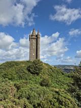 Scrabo TowerHeritage attraction · 2.5 mi
 Castle Espie Wetland CentreNature reserve · 2.7 mi
 Kiltonga Nature ReserveNature reserve · 3.5 mi
 Comber GreenwayWalking route · 3.7 mi
 Post-Medieval church & graveyard in TullynakillPost-Medieval church & graveyard · 4.1 mi
 Braniel HillMountain / peak · 4.2 mi
More historic places in County Down · All of County Down
What do you know about this place?