What is recorded here
From OpenStreetMap (© OpenStreetMap contributors) n332373439
Places near here
Photo credits
- Robert Bone, Geograph · CC BY-SA 2.0
- N Chadwick, Wikimedia Commons · CC BY-SA 2.0
- National Inventory of Architectural Heritage
- No machine-readable author provided. Bogman assumed (based on copyright claims)., Wikimedia Commons · CC BY-SA 2.5
- Rossographer, Geograph · CC BY-SA 2.0
- Rossographer, Wikimedia Commons · CC BY-SA 2.0
- Kenneth Allen, Wikimedia Commons · CC BY-SA 2.0
- Kenneth Allen, Geograph · CC BY-SA 2.0
- Wilson44691, Wikimedia Commons · CC0
- Bart Whelan, Wikimedia Commons · CC BY-SA 2.0
- Dennis Reynolds, Geograph · CC BY-SA 2.0
 Sliabh TuaidhMountain / peak · 1.2 mi
Explorer Tom Sliabh Tuaidh offers a proper trig point at 511m for you to tick off your list. The craggy face of the West Top beyond looks like it’s been carved by ancient hands.
 Maghera CavesSea caves · 2.7 mi
Explorer Tom Maghera Caves have enough openings to make me lose count: thirteen beside Maghera Strand, including Uaimh a' nDaoine, the Cave of the People. That name gives my imagination a full day's work. These are real sea caves, though, so I would keep my distance from the entrances.
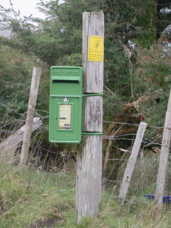 post box2.7 mi
Explorer Tom The post box in Mín Na Croise has 'Post Office' in raised letters and a Scottish foundry mark at its base, but no royal cipher. All that iron, and not one crown! I want to know how many letters have slipped through its little flap.
 Maghera WaterfallWaterfall · 2.8 mi
Explorer Tom Maghera Waterfall tumbles through County Donegal, and I bet the mist smells like ancient secrets just waiting to be shared.
 Assaranca WaterfallWaterfall · 2.9 mi
Explorer Tom Assaranca Waterfall tumbles right beside the road between Ardara and Maghera, making it an incredibly easy stop to see.
 Maghera StrandBeach / strand · 3.1 mi
Explorer Tom Maghera Strand put mountains behind the sand and caves in the cliffs, as if one dramatic backdrop would not do. The local beach guide places it beside Slievetooey and warns about high tides and currents. I would admire the cave mouths from a safe spot and let current local advice decide whether a closer look is sensible.
 Stranakirk DolmenNamed dolmen · 3.8 mi
Explorer Tom Stranakirk Dolmen is a simple little stone table with three legs, resting peacefully in the field. It’s not some massive, world-famous masterpiece, but seeing that rounded capstone balanced on its uprights still feels like spotting a secret handshake between the earth and the sky.
 IllancreeveIslet · 3.8 mi
Explorer Tom Illancreeve stands near Laconnel in County Donegal, an islet visible from the north with a rugged, enduring presence.
 Glengesh PassViewpoint · 3.9 mi
Explorer Tom Glengesh Pass offers a spectacular view looking NE into Ardara, giving you a front-row seat to the heart of County Donegal’s drama.
 O'Boyle's Fort at StonebrookNamed fort remains · 4.0 mi
Explorer Tom O'Boyle's Fort at Stonebrook is basically just curving stones pretending to be a mighty stronghold. It’s near Ardara and sounds like it belonged to some serious local legends, though the walls might not hold up against much more than a strong breeze.
 CroaghstraleelMountain / peak · 4.0 mi
Explorer Tom On the road between Carrick and Meenaneary lies Croaghstraleel, a peak in County Donegal with a scenic backdrop.
 Bun na nEasann BridgeBridge · 4.7 mi
Explorer Tom Bun na nEasann Bridge has a V-shaped cutwater on its central pier above a tributary of the Ballaghdoo River. A bridge with a serious stone nose! If it could sniff for fish, the two round arches would keep their composure.
More mountains and hills in County Donegal · All of County Donegal

What do you know about this place?Tap to add a comment or ask a question