
What is recorded here
In rolling pasture within 100m of the River Moy. Three orthostats stand on an oval stony mound (11.7m E-W; 7.7m N-S; H 0.6m). Two of the orthostats, both low stones, are opposite each other close to the middle of the mound and seem to represent a gallery aligned approximately E-W. Immediately E of these the tops of…
Read the whole record
From the National Monuments Service (Archaeological Survey of Ireland) record SL032-003
Places near here
Photo credits
- Maker not stated on source page, www.alamy.com
- Maker not stated on source page, commons.wikimedia.org
- Maker not stated on source page, www.pinterest.com
- Maker not stated on source page, www.rte.ie
- Maker not stated on source page, uk.pinterest.com
- Maker not stated on source page, www.dreamstime.com
- National Inventory of Architectural Heritage
- Kmcnamee, Wikimedia Commons · CC BY-SA 4.0
- Tubbercurry GAA Club (official website publisher); individual aerial photographer not named, tubbercurrygaa.com
 Bullaun stone in CarrownaleckBullaun stone · 798 yd
Explorer Tom Bullaun stone in Carrownaleck is just chilling in a modern garden, looking very comfortable in its mossy sweater. The…
 Kilcummin GraveyardGraveyard · 823 yd
Explorer Tom Kilcummin Graveyard is famous locally because a fiddler played there all night and never stopped to pee once. He…
 Church in Ballyglass (leyny By.)Church · 1317 yd
Explorer Tom Church in Ballyglass has a hidden message in its stones that says 'we were here briefly,' which is very honest for an…
 Cloonacool GAA Community FieldGAA ground · 1325 yd
 Cross-inscribed stone in CarrownaleckCross-inscribed stone · 1379 yd
Explorer Tom Cross-inscribed stone in Carrownaleck is a broken T-shaped boulder in the Ox Mountains foothills that looks like it got…
 Fairy fort / earthen ringfort in MullaghanarryFairy fort / earthen ringfort · 1.8 mi
Explorer Tom Fairy fort / earthen ringfort in Mullaghanarry would write 'looking for a solid bank partner' on its profile. It's got…
 Cloonacool GraveyardCemetery · 1.9 mi
Explorer Tom Cloonacool Graveyard is cursed so that anyone who doesn’t wave politely gets a sudden itch they can’t scratch for…
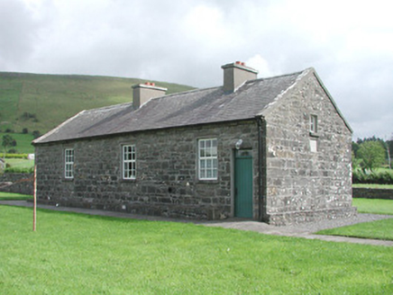 Carrowmore National SchoolSchool · 1.9 mi
Explorer Tom Carrowmore National School is a tiny building at Carrowmore Crossroads, still holding onto its slate roof and rubble…
 Nace O'Dowd Park, Coolaney/Mullinabreena GAAGAA ground · 3.5 mi
 Fairy fort / earthen ringfort in AchonryFairy fort / earthen ringfort · 3.7 mi
Explorer Tom This Achonry fort is writing its dating profile right now; looking for someone who appreciates a good slope. The ditch…
Enclosure in AchonryEnclosure · 3.9 miExplorer Tom This Achonry enclosure is on a bog island, which means it argues with everyone about who owns the mud. The whole parish…
 Kilcoyne Park, Tubbercurry GAAGAA ground · 4.0 mi
More archaeology and monuments in County Sligo · All of County Sligo

What do you know about this place?Tap to add a comment or ask a question